Nanfeng geodata
Nanfeng (Guangdong) is a seat of a fourth-order administrative division; located in China in Asia/Shanghai (GMT+8) time zone. With population of 86,129 people, there are 494 cities with bigger population in this country. Compared to other cities in China, 91.2% of cities are located further ↑North; 63.5% of cities are located further →East and 74.1% of cities have higher elevation than Nanfeng. Note1


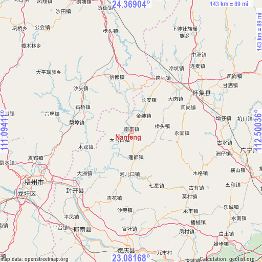
Nanfeng GPS coordinates[2]
23° 43' 37.02" North, 111° 47' 50.028" East
| Map corner | latitude | longitude |
|---|---|---|
| Upper-left | 24.36904°, | 111.09411° |
| Center: | 23.72695°, | 111.79723° |
| Lower-right: | 23.08168°, | 112.50036° |
| Map W x H: | 143.1×143.1 km | = 88.9×88.9mi |
| max Lat: | 53.31946° ⇑91.2% North |
| Nanfeng: | 23.72695° |
| min Lat: | ⇓8.8% South 18.22056° |
| min Long | Nanfeng | max Long |
| 75.07348° | 111.79723° | 134.28917° |
| W 36.5%⇐ | ⇒63.5% E |
Elevation
Elevation of Nanfeng is 39 m = 128 ft, and this is 445.8 m = 1463 ft below average elevation for this country.
| Max E: |
5622 m = 18445 ft | 74.1% |
| Avg. | 484.8 m = 1591 ft | |
| Nanfeng | 39 m = 128 ft | |
Min E: |
-3 m = -10 ft | 25.9% |
See also: Nanfeng elevation on elevation.city.
Geographical zone
Nanfeng is located in North temperate zone (between Tropic of Cancer and the Arctic Circle). Distance of this Northern Tropic circle is 32.3 km =20.1 mi to South.| Distance of | km | miles | from Nanfeng |
|---|---|---|---|
| North Pole | 7368.9 | 4578.8 | to North |
| Arctic Circle | 4763 | 2959.6 | to North |
| Tropic Cancer | 32.3 | 20.1 | to South |
| Equator | 2638.2 | 1639.3 | to South |


Nearby cities:
15 places around Nanfeng: (largest is in red/bold)
• Baigou
29.6 km =18.4 mi,  214°
214°
• Chang’an
19.8 km =12.3 mi,  29°
29°
• Dagang
29.9 km =18.6 mi,  54°
54°
• Dayukou
7.8 km =4.8 mi,  233°
233°
• Duping
14.9 km =9.3 mi, 228°
• Ganping
33.9 km =21.1 mi, 31°
• He’erkou
24.2 km =15 mi,  182°
182°
• Jinzhuang
10.8 km =6.7 mi,  39°
39°
• Liandu
15.4 km =9.6 mi,  171°
171°
• Liangcun
33.2 km =20.6 mi, 41°
• Qiaotou
17.7 km =11 mi,  83°
83°
• Shidong
29.9 km =18.6 mi,  113°
113°
• Yonggu
27.7 km =17.2 mi,  92°
92°
• Yulao
26.3 km =16.3 mi,  193°
193°
• Zhagang
33 km =20.5 mi,  69°
69°
Sources, notices
• [Note1] Compared only with cities in China existing in our database
• [Src1] Map data: © OpenStreetMap contributors (CC-BY-SA)
• [Src2] Other city data from geonames.org with taken over terms of usage.
• [Src3] Geographical zone / Annual Mean Temperature by Robert A. Rohde @ Wikipedia
