Jiecun geodata
Jiecun (Jiangxi) is a seat of a fourth-order administrative division; located in China in Asia/Shanghai (GMT+8) time zone. In our database, there are 1268 cities with bigger population. Compared to other cities in China, 81.4% of cities are located further ↑North; 56.7% of cities are located further ←West and 53.2% of cities have lower elevation than Jiecun. Note1


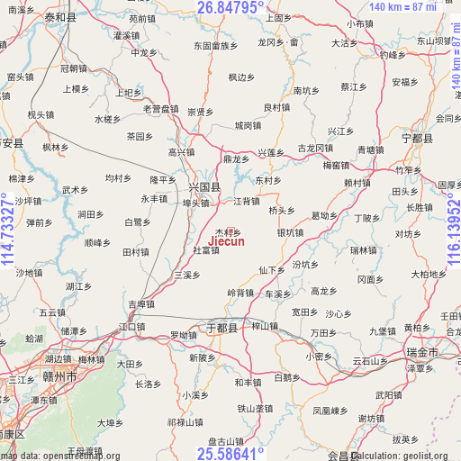
Jiecun GPS coordinates[2]
26° 13' 8.004" North, 115° 26' 11.004" East
| Map corner | latitude | longitude |
|---|---|---|
| Upper-left | 26.84795°, | 114.73327° |
| Center: | 26.21889°, | 115.43639° |
| Lower-right: | 25.58641°, | 116.13952° |
| Map W x H: | 140.3×140.3 km | = 87.2×87.2mi |
| max Lat: | 53.31946° ⇑81.4% North |
| Jiecun: | 26.21889° |
| min Lat: | ⇓18.6% South 18.22056° |
| min Long | Jiecun | max Long |
| 75.07348° | 115.43639° | 134.28917° |
| W 56.7%⇐ | ⇒43.3% E |
Elevation
Elevation of Jiecun is 190 m = 623 ft, and this is 294.8 m = 967 ft below average elevation for this country.
| Max E: |
5622 m = 18445 ft | 46.8% |
| Avg. | 484.8 m = 1591 ft | |
| Jiecun | 190 m = 623 ft | |
Min E: |
-3 m = -10 ft | 53.2% |
See also: China elevation on elevation.city.
Geographical zone
Jiecun is located in North temperate zone (between Tropic of Cancer and the Arctic Circle). Distance of this Northern Tropic circle is 309.3 km =192.2 mi to South.| Distance of | km | miles | from Jiecun |
|---|---|---|---|
| North Pole | 7091.8 | 4406.6 | to North |
| Arctic Circle | 4485.9 | 2787.4 | to North |
| Tropic Cancer | 309.3 | 192.2 | to South |
| Equator | 2915.3 | 1811.5 | to South |


Nearby cities:
15 places around Jiecun: (largest is in red/bold)
• Butou
12.7 km =7.9 mi,  309°
309°
• Changgang
17.8 km =11.1 mi,  336°
336°
• Chexi
23.9 km =14.9 mi,  142°
142°
• Dinglong
21.9 km =13.6 mi,  4°
4°
• Dongcun
19.8 km =12.3 mi,  35°
35°
• Fenkeng
25 km =15.5 mi,  113°
113°
• Jiangbei
10.2 km =6.3 mi,  26°
26°
• Lingbei
18.9 km =11.7 mi,  170°
170°
• Longkou
14 km =8.7 mi,  254°
254°
• Ma’an
11.2 km =7 mi,  95°
95°
• Sanxixiang
19 km =11.8 mi,  226°
226°
• Shefu
9.2 km =5.7 mi, 231°
• Xianxia
17.3 km =10.7 mi,  132°
132°
• Yinkeng
17.8 km =11.1 mi,  91°
91°
• Yongfeng
24.7 km =15.3 mi,  293°
293°
Sources, notices
• [Note1] Compared only with cities in China existing in our database
• [Src1] Map data: © OpenStreetMap contributors (CC-BY-SA)
• [Src2] Other city data from geonames.org with taken over terms of usage.
• [Src3] Geographical zone / Annual Mean Temperature by Robert A. Rohde @ Wikipedia
