Furong geodata
Furong (Jiangxi) is a seat of a third-order administrative division; located in China in Asia/Shanghai (GMT+8) time zone. In our database, there are 1268 cities with bigger population. Compared to other cities in China, 80.6% of cities are located further ↑North; 52.9% of cities are located further ←West and 53.7% of cities have higher elevation than Furong. Note1


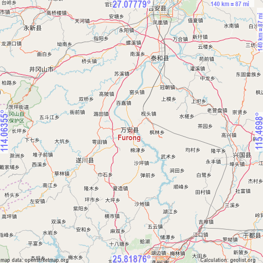
Furong GPS coordinates[2]
26° 27' 0" North, 114° 46' 0.012" East
| Map corner | latitude | longitude |
|---|---|---|
| Upper-left | 27.07779°, | 114.06355° |
| Center: | 26.45°, | 114.76667° |
| Lower-right: | 25.81876°, | 115.4698° |
| Map W x H: | 140×140 km | = 87×87mi |
| max Lat: | 53.31946° ⇑80.6% North |
| Furong: | 26.45° |
| min Lat: | ⇓19.4% South 18.22056° |
| min Long | Furong | max Long |
| 75.07348° | 114.76667° | 134.28917° |
| W 52.9%⇐ | ⇒47.1% E |
Elevation
Elevation of Furong is 139 m = 456 ft, and this is 345.8 m = 1135 ft below average elevation for this country.
| Max E: |
5622 m = 18445 ft | 53.7% |
| Avg. | 484.8 m = 1591 ft | |
| Furong | 139 m = 456 ft | |
Min E: |
-3 m = -10 ft | 46.3% |
See also: China elevation on elevation.city.
Geographical zone
Furong is located in North temperate zone (between Tropic of Cancer and the Arctic Circle). Distance of this Northern Tropic circle is 335 km =208.2 mi to South.| Distance of | km | miles | from Furong |
|---|---|---|---|
| North Pole | 7066.1 | 4390.7 | to North |
| Arctic Circle | 4460.2 | 2771.4 | to North |
| Tropic Cancer | 335 | 208.2 | to South |
| Equator | 2941 | 1827.5 | to South |


Nearby cities:
15 places around Furong: (largest is in red/bold)
• Bailu
44.4 km =27.6 mi,  121°
121°
• Baoshan
26.4 km =16.4 mi, 115°
• Chayuan
39.3 km =24.4 mi,  85°
85°
• Chengjiang
41.3 km =25.7 mi,  18°
18°
• Gaoxing
51.4 km =31.9 mi, 92°
• Guanxi
48.8 km =30.3 mi,  46°
46°
• Jiantian
31.8 km =19.8 mi,  127°
127°
• Laoyingpan
46.4 km =28.8 mi,  74°
74°
• Longping
47.8 km =29.7 mi,  102°
102°
• Quanjiang
29.7 km =18.5 mi,  238°
238°
• Shangyi
39.1 km =24.3 mi, 65°
• Shuicha
30.9 km =19.2 mi, 74°
• Shunfeng
39.1 km =24.3 mi,  137°
137°
• Yongfeng
46.9 km =29.1 mi,  109°
109°
• Zhonglong
49.2 km =30.6 mi, 54°
Sources, notices
• [Note1] Compared only with cities in China existing in our database
• [Src1] Map data: © OpenStreetMap contributors (CC-BY-SA)
• [Src2] Other city data from geonames.org with taken over terms of usage.
• [Src3] Geographical zone / Annual Mean Temperature by Robert A. Rohde @ Wikipedia
