Mahekou geodata
Mahekou (Hunan) is a seat of a fourth-order administrative division; located in China in Asia/Shanghai (GMT+8) time zone. In our database, there are 1268 cities with bigger population. Compared to other cities in China, 62% of cities are located further ↑North; 61.3% of cities are located further →East and 77.2% of cities have higher elevation than Mahekou. Note1


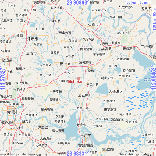
Mahekou GPS coordinates[2]
29° 17' 53.988" North, 112° 16' 53.004" East
| Map corner | latitude | longitude |
|---|---|---|
| Upper-left | 29.90966°, | 111.57827° |
| Center: | 29.29833°, | 112.28139° |
| Lower-right: | 28.68331°, | 112.98452° |
| Map W x H: | 136.4×136.4 km | = 84.8×84.8mi |
| max Lat: | 53.31946° ⇑62% North |
| Mahekou: | 29.29833° |
| min Lat: | ⇓38% South 18.22056° |
| min Long | Mahekou | max Long |
| 75.07348° | 112.28139° | 134.28917° |
| W 38.7%⇐ | ⇒61.3% E |
Elevation
Elevation of Mahekou is 32 m = 105 ft, and this is 452.8 m = 1486 ft below average elevation for this country.
| Max E: |
5622 m = 18445 ft | 77.2% |
| Avg. | 484.8 m = 1591 ft | |
| Mahekou | 32 m = 105 ft | |
Min E: |
-3 m = -10 ft | 22.8% |
See also: China elevation on elevation.city.
Geographical zone
Mahekou is located in North temperate zone (between Tropic of Cancer and the Arctic Circle). Distance of this Northern Tropic circle is 651.7 km =404.9 mi to South.| Distance of | km | miles | from Mahekou |
|---|---|---|---|
| North Pole | 6749.4 | 4193.9 | to North |
| Arctic Circle | 4143.5 | 2574.7 | to North |
| Tropic Cancer | 651.7 | 404.9 | to South |
| Equator | 3257.7 | 2024.2 | to South |


Nearby cities:
15 places around Mahekou: (largest is in red/bold)
• Anfeng
24.7 km =15.3 mi,  302°
302°
• Anning
30.3 km =18.8 mi,  318°
318°
• Anxiang
17 km =10.6 mi,  311°
311°
• Anyu
20.3 km =12.6 mi, 295°
• Baohedi
30.6 km =19 mi,  292°
292°
• Datong
29.5 km =18.3 mi,  153°
153°
• Haozigang
22 km =13.7 mi,  262°
262°
• Huangzhuzhou
27.7 km =17.2 mi,  223°
223°
• Meitianhu
26.3 km =16.3 mi,  17°
17°
• Nanzhou
13.6 km =8.5 mi,  59°
59°
• Sanchahe
20.1 km =12.5 mi,  175°
175°
• Shimeitang
23.6 km =14.7 mi,  240°
240°
• Xinhe
27.2 km =16.9 mi, 58°
• Zhonghekou
28.6 km =17.8 mi,  275°
275°
• Zhufeng
31.5 km =19.6 mi,  251°
251°
Sources, notices
• [Note1] Compared only with cities in China existing in our database
• [Src1] Map data: © OpenStreetMap contributors (CC-BY-SA)
• [Src2] Other city data from geonames.org with taken over terms of usage.
• [Src3] Geographical zone / Annual Mean Temperature by Robert A. Rohde @ Wikipedia
