Lianghekou geodata
Lianghekou (Hunan) is a seat of a fourth-order administrative division; located in China in Asia/Shanghai (GMT+8) time zone. In our database, there are 1268 cities with bigger population. Compared to other cities in China, 60.3% of cities are located further ↑North; 71.1% of cities are located further →East and 65.2% of cities have lower elevation than Lianghekou. Note1


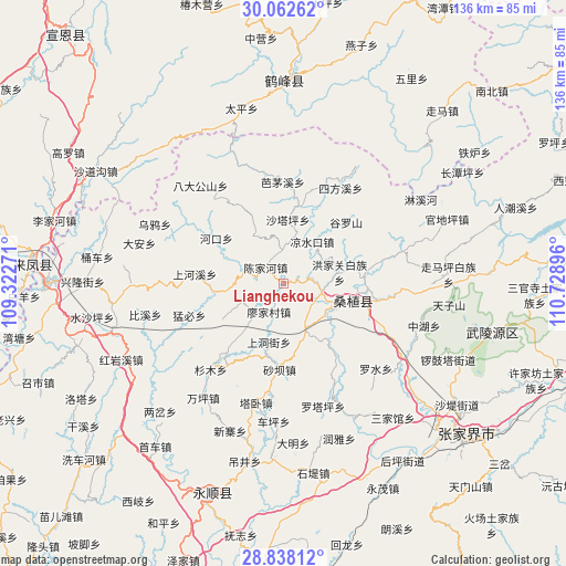
Lianghekou GPS coordinates[2]
29° 27' 7.992" North, 110° 1' 32.988" East
| Map corner | latitude | longitude |
|---|---|---|
| Upper-left | 30.06262°, | 109.32271° |
| Center: | 29.45222°, | 110.02583° |
| Lower-right: | 28.83812°, | 110.72896° |
| Map W x H: | 136.2×136.2 km | = 84.6×84.6mi |
| max Lat: | 53.31946° ⇑60.3% North |
| Lianghekou: | 29.45222° |
| min Lat: | ⇓39.7% South 18.22056° |
| min Long | Lianghekou | max Long |
| 75.07348° | 110.02583° | 134.28917° |
| W 28.9%⇐ | ⇒71.1% E |
Elevation
Elevation of Lianghekou is 331 m = 1086 ft, and this is 153.8 m = 505 ft below average elevation for this country.
| Max E: |
5622 m = 18445 ft | 34.8% |
| Avg. | 484.8 m = 1591 ft | |
| Lianghekou | 331 m = 1086 ft | |
Min E: |
-3 m = -10 ft | 65.2% |
See also: China elevation on elevation.city.
Geographical zone
Lianghekou is located in North temperate zone (between Tropic of Cancer and the Arctic Circle). Distance of this Northern Tropic circle is 668.9 km =415.6 mi to South.| Distance of | km | miles | from Lianghekou |
|---|---|---|---|
| North Pole | 6732.3 | 4183.3 | to North |
| Arctic Circle | 4126.4 | 2564 | to North |
| Tropic Cancer | 668.9 | 415.6 | to South |
| Equator | 3274.8 | 2034.9 | to South |


Nearby cities:
15 places around Lianghekou: (largest is in red/bold)
• Chenjiahe
6.1 km =3.8 mi,  308°
308°
• Guanba
18.4 km =11.4 mi,  198°
198°
• Hongjiaguan
13.9 km =8.6 mi,  78°
78°
• Jianjiapo
13.1 km =8.1 mi,  328°
328°
• Liangshuikou
12 km =7.5 mi,  34°
34°
• Lifuta
12.9 km =8 mi,  158°
158°
• Liyuan
14.1 km =8.8 mi,  116°
116°
• Miaojia
7.5 km =4.7 mi, 203°
• Shangdongjie
14.1 km =8.8 mi, 195°
• Shataping
15.2 km =9.4 mi,  4°
4°
• Taozixi
16.2 km =10.1 mi,  170°
170°
• Wanmingang
11.4 km =7.1 mi,  244°
244°
• Xiaobutou
7 km =4.3 mi, 82°
• Yanwukou
11.9 km =7.4 mi,  297°
297°
• Zhangjiaqiao
12.8 km =8 mi,  61°
61°
Sources, notices
• [Note1] Compared only with cities in China existing in our database
• [Src1] Map data: © OpenStreetMap contributors (CC-BY-SA)
• [Src2] Other city data from geonames.org with taken over terms of usage.
• [Src3] Geographical zone / Annual Mean Temperature by Robert A. Rohde @ Wikipedia
