Chenjiahe geodata
Chenjiahe (Hunan) is a seat of a fourth-order administrative division; located in China in Asia/Shanghai (GMT+8) time zone. In our database, there are 1268 cities with bigger population. Compared to other cities in China, 59.9% of cities are located further ↑North; 71.3% of cities are located further →East and 65.3% of cities have lower elevation than Chenjiahe. Note1


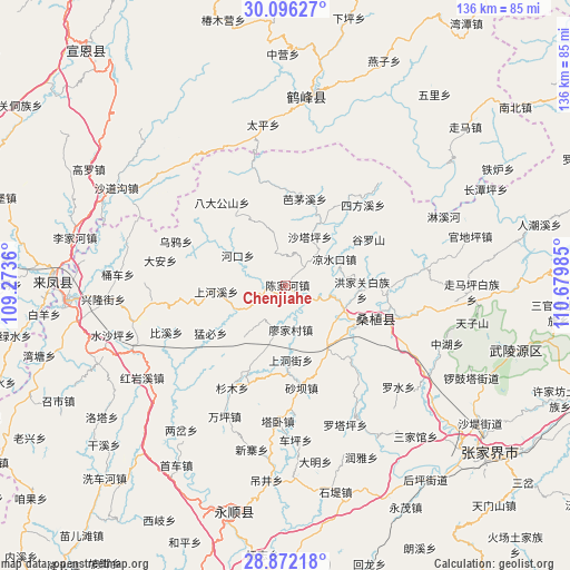
Chenjiahe GPS coordinates[2]
29° 29' 9.852" North, 109° 58' 36.192" East
| Map corner | latitude | longitude |
|---|---|---|
| Upper-left | 30.09627°, | 109.2736° |
| Center: | 29.48607°, | 109.97672° |
| Lower-right: | 28.87218°, | 110.67985° |
| Map W x H: | 136.1×136.1 km | = 84.6×84.6mi |
| max Lat: | 53.31946° ⇑59.9% North |
| Chenjiahe: | 29.48607° |
| min Lat: | ⇓40.1% South 18.22056° |
| min Long | Chenjiahe | max Long |
| 75.07348° | 109.97672° | 134.28917° |
| W 28.7%⇐ | ⇒71.3% E |
Elevation
Elevation of Chenjiahe is 332 m = 1089 ft, and this is 152.8 m = 501 ft below average elevation for this country.
| Max E: |
5622 m = 18445 ft | 34.7% |
| Avg. | 484.8 m = 1591 ft | |
| Chenjiahe | 332 m = 1089 ft | |
Min E: |
-3 m = -10 ft | 65.3% |
See also: China elevation on elevation.city.
Geographical zone
Chenjiahe is located in North temperate zone (between Tropic of Cancer and the Arctic Circle). Distance of this Northern Tropic circle is 672.6 km =417.9 mi to South.| Distance of | km | miles | from Chenjiahe |
|---|---|---|---|
| North Pole | 6728.5 | 4180.9 | to North |
| Arctic Circle | 4122.6 | 2561.7 | to North |
| Tropic Cancer | 672.6 | 417.9 | to South |
| Equator | 3278.5 | 2037.2 | to South |


Nearby cities:
15 places around Chenjiahe: (largest is in red/bold)
• Hongjiaguan
18.4 km =11.4 mi,  93°
93°
• Jianjiapo
7.7 km =4.8 mi,  344°
344°
• Lianghekou
6.1 km =3.8 mi,  128°
128°
• Liangshuikou
13.1 km =8.1 mi,  62°
62°
• Lifuta
18.4 km =11.4 mi,  149°
149°
• Liyuan
20.1 km =12.5 mi,  120°
120°
• Miaojia
10.8 km =6.7 mi,  170°
170°
• Pailou
13.6 km =8.5 mi,  301°
301°
• Shangdongjie
17.4 km =10.8 mi,  176°
176°
• Shanghexi
16.9 km =10.5 mi,  265°
265°
• Shataping
12.9 km =8 mi,  27°
27°
• Wanmingang
10.3 km =6.4 mi,  212°
212°
• Xiaobutou
12 km =7.5 mi,  103°
103°
• Yanwukou
6.1 km =3.8 mi,  286°
286°
• Zhangjiaqiao
16.2 km =10.1 mi,  81°
81°
Sources, notices
• [Note1] Compared only with cities in China existing in our database
• [Src1] Map data: © OpenStreetMap contributors (CC-BY-SA)
• [Src2] Other city data from geonames.org with taken over terms of usage.
• [Src3] Geographical zone / Annual Mean Temperature by Robert A. Rohde @ Wikipedia
