Xiuxi geodata
Xiuxi (Hunan) is a populated place; located in China in Asia/Shanghai (GMT+8) time zone. With population of 1,000 people, there are 1171 cities with bigger population in this country. Compared to other cities in China, 74.3% of cities are located further ↑North; 70% of cities are located further →East and 54.6% of cities have higher elevation than Xiuxi. Note1


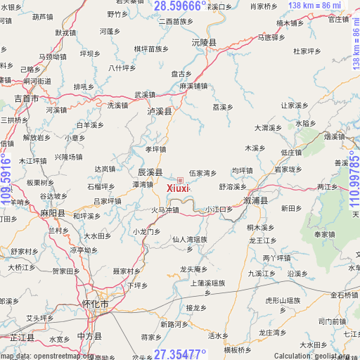
Xiuxi GPS coordinates[2]
27° 58' 39" North, 110° 17' 40.992" East
| Map corner | latitude | longitude |
|---|---|---|
| Upper-left | 28.59666°, | 109.5916° |
| Center: | 27.9775°, | 110.29472° |
| Lower-right: | 27.35477°, | 110.99785° |
| Map W x H: | 138.1×138.1 km | = 85.8×85.8mi |
| max Lat: | 53.31946° ⇑74.3% North |
| Xiuxi: | 27.9775° |
| min Lat: | ⇓25.7% South 18.22056° |
| min Long | Xiuxi | max Long |
| 75.07348° | 110.29472° | 134.28917° |
| W 30%⇐ | ⇒70% E |
Elevation
Elevation of Xiuxi is 134 m = 440 ft, and this is 350.8 m = 1151 ft below average elevation for this country.
| Max E: |
5622 m = 18445 ft | 54.6% |
| Avg. | 484.8 m = 1591 ft | |
| Xiuxi | 134 m = 440 ft | |
Min E: |
-3 m = -10 ft | 45.4% |
See also: China elevation on elevation.city.
Geographical zone
Xiuxi is located in North temperate zone (between Tropic of Cancer and the Arctic Circle). Distance of this Northern Tropic circle is 504.9 km =313.7 mi to South.| Distance of | km | miles | from Xiuxi |
|---|---|---|---|
| North Pole | 6896.3 | 4285.2 | to North |
| Arctic Circle | 4290.4 | 2665.9 | to North |
| Tropic Cancer | 504.9 | 313.7 | to South |
| Equator | 3110.8 | 1933 | to South |


Nearby cities:
15 places around Xiuxi: (largest is in red/bold)
• Anping
21.5 km =13.4 mi,  234°
234°
• Baisha
28 km =17.4 mi,  344°
344°
• Chenyang
12.7 km =7.9 mi,  289°
289°
• Chuanxi
21.8 km =13.5 mi,  351°
351°
• Huangxikou
30.1 km =18.7 mi,  162°
162°
• Huomachong
12.2 km =7.6 mi,  211°
211°
• Lufeng
29.6 km =18.4 mi,  104°
104°
• Muxi
31.5 km =19.6 mi,  66°
66°
• Pushi
22.7 km =14.1 mi,  300°
300°
• Tanwan
14.2 km =8.8 mi,  265°
265°
• Tianwan
14.2 km =8.8 mi, 335°
• Xianrenwan
25 km =15.5 mi,  172°
172°
• Xiaojiangkou
18.4 km =11.4 mi,  125°
125°
• Xiaolongmen
23.6 km =14.7 mi, 214°
• Yongping
21.2 km =13.2 mi,  23°
23°
Sources, notices
• [Note1] Compared only with cities in China existing in our database
• [Src1] Map data: © OpenStreetMap contributors (CC-BY-SA)
• [Src2] Other city data from geonames.org with taken over terms of usage.
• [Src3] Geographical zone / Annual Mean Temperature by Robert A. Rohde @ Wikipedia
