Wantan geodata
Wantan (Hubei) is a seat of a fourth-order administrative division; located in China in Asia/Shanghai (GMT+8) time zone. In our database, there are 1268 cities with bigger population. Compared to other cities in China, 53.5% of cities are located further ↑North; 69.4% of cities are located further →East and 87.9% of cities have lower elevation than Wantan. Note1


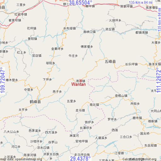
Wantan GPS coordinates[2]
30° 2' 53.844" North, 110° 25' 24.924" East
| Map corner | latitude | longitude |
|---|---|---|
| Upper-left | 30.65504°, | 109.72047° |
| Center: | 30.04829°, | 110.42359° |
| Lower-right: | 29.4378°, | 111.12672° |
| Map W x H: | 135.3×135.3 km | = 84.1×84.1mi |
| max Lat: | 53.31946° ⇑53.5% North |
| Wantan: | 30.04829° |
| min Lat: | ⇓46.5% South 18.22056° |
| min Long | Wantan | max Long |
| 75.07348° | 110.42359° | 134.28917° |
| W 30.6%⇐ | ⇒69.4% E |
Elevation
Elevation of Wantan is 1173 m = 3848 ft, and this is 688.2 m = 2258 ft above average elevation for this country.
| Max E: |
5622 m = 18445 ft | 12.1% |
| Wantan | 1173 m 3848 ft | |
| Avg. | 484.8 m = 1591 ft | |
Min E: |
-3 m = -10 ft | 87.9% |
See also: China elevation on elevation.city.
Geographical zone
Wantan is located in North temperate zone (between Tropic of Cancer and the Arctic Circle). Distance of this Northern Tropic circle is 735.1 km =456.8 mi to South.| Distance of | km | miles | from Wantan |
|---|---|---|---|
| North Pole | 6666 | 4142.1 | to North |
| Arctic Circle | 4060.1 | 2522.8 | to North |
| Tropic Cancer | 735.1 | 456.8 | to South |
| Equator | 3341.1 | 2076.1 | to South |


Nearby cities:
15 places around Wantan: (largest is in red/bold)
• Baiguo
18.5 km =11.5 mi,  170°
170°
• Caihua
18.7 km =11.6 mi,  7°
7°
• Fujiayan
29.5 km =18.3 mi, 10°
• Jinguoping
33.3 km =20.7 mi,  324°
324°
• Majiagou
33.3 km =20.7 mi, 324°
• Nanzhen
23 km =14.3 mi,  148°
148°
• Nishi
36.4 km =22.6 mi,  110°
110°
• Niuzhuang
22.1 km =13.7 mi,  344°
344°
• Wufeng
30.7 km =19.1 mi,  56°
56°
• Wuli
18.5 km =11.5 mi,  204°
204°
• Wuyang
29.3 km =18.2 mi,  300°
300°
• Yanzi
21.5 km =13.4 mi,  245°
245°
• Zhenjiatai
39.8 km =24.7 mi, 172°
• Zhujiatai
35.1 km =21.8 mi, 167°
• Zouma
24.5 km =15.2 mi,  180°
180°
Sources, notices
• [Note1] Compared only with cities in China existing in our database
• [Src1] Map data: © OpenStreetMap contributors (CC-BY-SA)
• [Src2] Other city data from geonames.org with taken over terms of usage.
• [Src3] Geographical zone / Annual Mean Temperature by Robert A. Rohde @ Wikipedia
