Hongwei geodata
Hongwei (Fujian) is a seat of a fourth-order administrative division; located in China in Asia/Shanghai (GMT+8) time zone. In our database, there are 1268 cities with bigger population. Compared to other cities in China, 81.7% of cities are located further ↑North; 76% of cities are located further ←West and 83.9% of cities have higher elevation than Hongwei. Note1


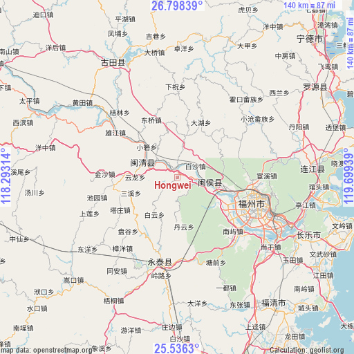
Hongwei GPS coordinates[2]
26° 10' 8.58" North, 118° 59' 46.536" East
| Map corner | latitude | longitude |
|---|---|---|
| Upper-left | 26.79839°, | 118.29314° |
| Center: | 26.16905°, | 118.99626° |
| Lower-right: | 25.5363°, | 119.69939° |
| Map W x H: | 140.3×140.3 km | = 87.2×87.2mi |
| max Lat: | 53.31946° ⇑81.7% North |
| Hongwei: | 26.16905° |
| min Lat: | ⇓18.3% South 18.22056° |
| min Long | Hongwei | max Long |
| 75.07348° | 118.99626° | 134.28917° |
| W 76%⇐ | ⇒24% E |
Elevation
Elevation of Hongwei is 18 m = 59 ft, and this is 466.8 m = 1531 ft below average elevation for this country.
| Max E: |
5622 m = 18445 ft | 83.9% |
| Avg. | 484.8 m = 1591 ft | |
| Hongwei | 18 m = 59 ft | |
Min E: |
-3 m = -10 ft | 16.1% |
See also: China elevation on elevation.city.
Geographical zone
Hongwei is located in North temperate zone (between Tropic of Cancer and the Arctic Circle). Distance of this Northern Tropic circle is 303.8 km =188.8 mi to South.| Distance of | km | miles | from Hongwei |
|---|---|---|---|
| North Pole | 7097.3 | 4410.1 | to North |
| Arctic Circle | 4491.4 | 2790.8 | to North |
| Tropic Cancer | 303.8 | 188.8 | to South |
| Equator | 2909.7 | 1808 | to South |


Nearby cities:
15 places around Hongwei: (largest is in red/bold)
• Baisha
8.5 km =5.3 mi,  58°
58°
• Baiyun
17.3 km =10.7 mi,  211°
211°
• Baizhang
19 km =11.8 mi,  274°
274°
• Danyun
19.6 km =12.2 mi,  172°
172°
• Daping
16.8 km =10.4 mi,  10°
10°
• Jingxi
18.5 km =11.5 mi,  103°
103°
• Meicheng
14.4 km =8.9 mi,  290°
290°
• Meipu
11.1 km =6.9 mi,  295°
295°
• Meixi
12.5 km =7.8 mi, 290°
• Rong’an
13.4 km =8.3 mi,  111°
111°
• Sanxi
19.3 km =12 mi,  251°
251°
• Shangjie
20.9 km =13 mi,  115°
115°
• Xiaoruo
17.3 km =10.7 mi,  314°
314°
• Yunlong
16.6 km =10.3 mi, 270°
• Zhuqi
10.8 km =6.7 mi, 102°
Sources, notices
• [Note1] Compared only with cities in China existing in our database
• [Src1] Map data: © OpenStreetMap contributors (CC-BY-SA)
• [Src2] Other city data from geonames.org with taken over terms of usage.
• [Src3] Geographical zone / Annual Mean Temperature by Robert A. Rohde @ Wikipedia
