Rong’an geodata
Rong’an (Fujian) is a populated place; located in China in Asia/Shanghai (GMT+8) time zone. With population of 5,510 people, there are 858 cities with bigger population in this country. Compared to other cities in China, 81.8% of cities are located further ↑North; 76.7% of cities are located further ←West and 85.5% of cities have higher elevation than Rong’an. Note1


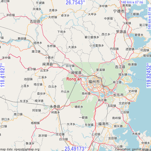
Rong’an GPS coordinates[2]
26° 7' 28.992" North, 119° 7' 17.004" East
| Map corner | latitude | longitude |
|---|---|---|
| Upper-left | 26.7543°, | 118.41827° |
| Center: | 26.12472°, | 119.12139° |
| Lower-right: | 25.49173°, | 119.82452° |
| Map W x H: | 140.4×140.4 km | = 87.2×87.2mi |
| max Lat: | 53.31946° ⇑81.8% North |
| Rong’an: | 26.12472° |
| min Lat: | ⇓18.2% South 18.22056° |
| min Long | Rong’an | max Long |
| 75.07348° | 119.12139° | 134.28917° |
| W 76.7%⇐ | ⇒23.3% E |
Elevation
Elevation of Rong’an is 15 m = 49 ft, and this is 469.8 m = 1541 ft below average elevation for this country.
| Max E: |
5622 m = 18445 ft | 85.5% |
| Avg. | 484.8 m = 1591 ft | |
| Rong’an | 15 m = 49 ft | |
Min E: |
-3 m = -10 ft | 14.5% |
See also: China elevation on elevation.city.
Geographical zone
Rong’an is located in North temperate zone (between Tropic of Cancer and the Arctic Circle). Distance of this Northern Tropic circle is 298.9 km =185.7 mi to South.| Distance of | km | miles | from Rong’an |
|---|---|---|---|
| North Pole | 7102.3 | 4413.2 | to North |
| Arctic Circle | 4496.4 | 2793.9 | to North |
| Tropic Cancer | 298.9 | 185.7 | to South |
| Equator | 2904.8 | 1805 | to South |


Nearby cities:
15 places around Rong’an: (largest is in red/bold)
• Baisha
10.8 km =6.7 mi,  330°
330°
• Guxi
16.7 km =10.4 mi,  103°
103°
• Hongshan
15.8 km =9.8 mi,  109°
109°
• Hongtang
12.5 km =7.8 mi,  118°
118°
• Hongwei
13.4 km =8.3 mi,  291°
291°
• Huada
16.8 km =10.4 mi, 99°
• Huai’an
10.4 km =6.5 mi, 105°
• Jianxin
12.4 km =7.7 mi, 119°
• Jingxi
5.5 km =3.4 mi,  84°
84°
• Lingtou
16.7 km =10.4 mi,  64°
64°
• Nanjie
17.3 km =10.7 mi, 103°
• Shangjie
7.6 km =4.7 mi, 123°
• Shoushan
17.5 km =10.9 mi,  40°
40°
• Wufeng
15.8 km =9.8 mi, 97°
• Zhuqi
3.3 km =2.1 mi,  324°
324°
Sources, notices
• [Note1] Compared only with cities in China existing in our database
• [Src1] Map data: © OpenStreetMap contributors (CC-BY-SA)
• [Src2] Other city data from geonames.org with taken over terms of usage.
• [Src3] Geographical zone / Annual Mean Temperature by Robert A. Rohde @ Wikipedia
