Guanjiabao geodata
Guanjiabao (Shanxi) is a seat of a fourth-order administrative division; located in China in Asia/Shanghai (GMT+8) time zone. In our database, there are 1268 cities with bigger population. Compared to other cities in China, 87.1% of cities are located further ↓South; 58.2% of cities are located further →East and 89.2% of cities have lower elevation than Guanjiabao. Note1


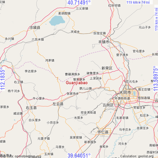
Guanjiabao GPS coordinates[2]
40° 10' 47.424" North, 112° 53' 11.832" East
| Map corner | latitude | longitude |
|---|---|---|
| Upper-left | 40.71491°, | 112.1835° |
| Center: | 40.17984°, | 112.88662° |
| Lower-right: | 39.64051°, | 113.58975° |
| Map W x H: | 119.5×119.5 km | = 74.3×74.3mi |
| max Lat: | 53.31946° ⇑12.9% North |
| Guanjiabao: | 40.17984° |
| min Lat: | ⇓87.1% South 18.22056° |
| min Long | Guanjiabao | max Long |
| 75.07348° | 112.88662° | 134.28917° |
| W 41.8%⇐ | ⇒58.2% E |
Elevation
Elevation of Guanjiabao is 1291 m = 4236 ft, and this is 806.2 m = 2645 ft above average elevation for this country.
| Max E: |
5622 m = 18445 ft | 10.8% |
| Guanjiabao | 1291 m 4236 ft | |
| Avg. | 484.8 m = 1591 ft | |
Min E: |
-3 m = -10 ft | 89.2% |
See also: China elevation on elevation.city.
Geographical zone
Guanjiabao is located in North temperate zone (between Tropic of Cancer and the Arctic Circle). Distance of this Northern Tropic circle is 1861.7 km =1156.8 mi to South.| Distance of | km | miles | from Guanjiabao |
|---|---|---|---|
| North Pole | 5539.5 | 3442.1 | to North |
| Arctic Circle | 2933.6 | 1822.9 | to North |
| Tropic Cancer | 1861.7 | 1156.8 | to South |
| Equator | 4467.6 | 2776 | to South |


Nearby cities:
15 places around Guanjiabao: (largest is in red/bold)
• Beichengqu
36.7 km =22.8 mi,  38°
38°
• Datong
35.7 km =22.2 mi,  105°
105°
• Dianwan
21.6 km =13.4 mi,  184°
184°
• Kouquan
29.8 km =18.5 mi,  132°
132°
• Madaotou
35.2 km =21.9 mi,  196°
196°
• Majunying
30.4 km =18.9 mi, 109°
• Niuxinbao
34 km =21.1 mi,  245°
245°
• Que’ershan
8.3 km =5.2 mi,  144°
144°
• Santun
17 km =10.6 mi,  238°
238°
• Shuiyao
30.4 km =18.9 mi, 180°
• Xihanling
35.2 km =21.9 mi,  121°
121°
• Xinrong
22.9 km =14.2 mi,  67°
67°
• Ya’erya
25.2 km =15.7 mi,  158°
158°
• Yunxing
25.7 km =16 mi,  218°
218°
• Zhangjiachang
11.7 km =7.3 mi, 203°
Sources, notices
• [Note1] Compared only with cities in China existing in our database
• [Src1] Map data: © OpenStreetMap contributors (CC-BY-SA)
• [Src2] Other city data from geonames.org with taken over terms of usage.
• [Src3] Geographical zone / Annual Mean Temperature by Robert A. Rohde @ Wikipedia
