Yong’an geodata
Yong’an (Heilongjiang) is a seat of a fourth-order administrative division; located in China in Asia/Shanghai (GMT+8) time zone. In our database, there are 1268 cities with bigger population. Compared to other cities in China, 96% of cities are located further ↓South; 96.2% of cities are located further ←West and 52.6% of cities have higher elevation than Yong’an. Note1


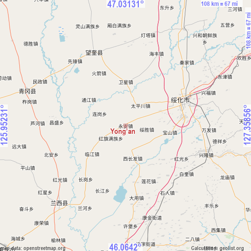
Yong’an GPS coordinates[2]
46° 32' 59.676" North, 126° 39' 19.548" East
| Map corner | latitude | longitude |
|---|---|---|
| Upper-left | 47.03131°, | 125.95231° |
| Center: | 46.54991°, | 126.65543° |
| Lower-right: | 46.0642°, | 127.35856° |
| Map W x H: | 107.5×107.5 km | = 66.8×66.8mi |
| max Lat: | 53.31946° ⇑4% North |
| Yong’an: | 46.54991° |
| min Lat: | ⇓96% South 18.22056° |
| min Long | Yong’an | max Long |
| 75.07348° | 126.65543° | 134.28917° |
| W 96.2%⇐ | ⇒3.8% E |
Elevation
Elevation of Yong’an is 146 m = 479 ft, and this is 338.8 m = 1112 ft below average elevation for this country.
| Max E: |
5622 m = 18445 ft | 52.6% |
| Avg. | 484.8 m = 1591 ft | |
| Yong’an | 146 m = 479 ft | |
Min E: |
-3 m = -10 ft | 47.4% |
See also: China elevation on elevation.city.
Geographical zone
Yong’an is located in North temperate zone (between Tropic of Cancer and the Arctic Circle). Distance of this North polar circle is 2225.3 km =1382.7 mi to North.| Distance of | km | miles | from Yong’an |
|---|---|---|---|
| North Pole | 4831.2 | 3002 | to North |
| Arctic Circle | 2225.3 | 1382.7 | to North |
| Tropic Cancer | 2569.9 | 1596.9 | to South |
| Equator | 5175.9 | 3216.2 | to South |


Nearby cities:
15 places around Yong’an: (largest is in red/bold)
• Baoshan
19.3 km =12 mi,  98°
98°
• Changgang
28.5 km =17.7 mi,  216°
216°
• Dayou
27.1 km =16.8 mi,  69°
69°
• Hongguang
27.7 km =17.2 mi,  120°
120°
• Hongqi
8.4 km =5.2 mi,  230°
230°
• Huojian
25.5 km =15.8 mi,  332°
332°
• Lianhua
25.6 km =15.9 mi,  158°
158°
• Linjiang
18.8 km =11.7 mi, 230°
• Suihua
27.8 km =17.3 mi, 68°
• Suisheng
9.4 km =5.8 mi, 99°
• Taipingchuan
10.6 km =6.6 mi,  36°
36°
• Tongjiang
19.4 km =12.1 mi,  305°
305°
• Weixing
18.7 km =11.6 mi,  0°
0°
• Xichangfa
14.3 km =8.9 mi,  168°
168°
• Xinhua
17.6 km =10.9 mi,  53°
53°
Sources, notices
• [Note1] Compared only with cities in China existing in our database
• [Src1] Map data: © OpenStreetMap contributors (CC-BY-SA)
• [Src2] Other city data from geonames.org with taken over terms of usage.
• [Src3] Geographical zone / Annual Mean Temperature by Robert A. Rohde @ Wikipedia
