Tongjiang geodata
Tongjiang (Heilongjiang) is a seat of a fourth-order administrative division; located in China in Asia/Shanghai (GMT+8) time zone. In our database, there are 1268 cities with bigger population. Compared to other cities in China, 96.2% of cities are located further ↓South; 96% of cities are located further ←West and 50.6% of cities have lower elevation than Tongjiang. Note1


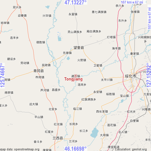
Tongjiang GPS coordinates[2]
46° 39' 6.408" North, 126° 26' 59.244" East
| Map corner | latitude | longitude |
|---|---|---|
| Upper-left | 47.13227°, | 125.74667° |
| Center: | 46.65178°, | 126.44979° |
| Lower-right: | 46.16698°, | 127.15292° |
| Map W x H: | 107.3×107.3 km | = 66.7×66.7mi |
| max Lat: | 53.31946° ⇑3.8% North |
| Tongjiang: | 46.65178° |
| min Lat: | ⇓96.2% South 18.22056° |
| min Long | Tongjiang | max Long |
| 75.07348° | 126.44979° | 134.28917° |
| W 96%⇐ | ⇒4% E |
Elevation
Elevation of Tongjiang is 170 m = 558 ft, and this is 314.8 m = 1033 ft below average elevation for this country.
| Max E: |
5622 m = 18445 ft | 49.4% |
| Avg. | 484.8 m = 1591 ft | |
| Tongjiang | 170 m = 558 ft | |
Min E: |
-3 m = -10 ft | 50.6% |
See also: China elevation on elevation.city.
Geographical zone
Tongjiang is located in North temperate zone (between Tropic of Cancer and the Arctic Circle). Distance of this North polar circle is 2214 km =1375.7 mi to North.| Distance of | km | miles | from Tongjiang |
|---|---|---|---|
| North Pole | 4819.9 | 2994.9 | to North |
| Arctic Circle | 2214 | 1375.7 | to North |
| Tropic Cancer | 2581.3 | 1603.9 | to South |
| Equator | 5187.2 | 3223.2 | to South |


Nearby cities:
15 places around Tongjiang: (largest is in red/bold)
• Bei’an
28.4 km =17.6 mi,  214°
214°
• Changsheng
17 km =10.6 mi,  235°
235°
• Hongqi
19.1 km =11.9 mi,  151°
151°
• Huojian
12 km =7.5 mi,  19°
19°
• Linjiang
23.4 km =14.5 mi,  176°
176°
• Luhe
24.3 km =15.1 mi,  245°
245°
• Minzheng
22.4 km =13.9 mi,  289°
289°
• Qinggang
26.5 km =16.5 mi,  277°
277°
• Suisheng
28.1 km =17.5 mi,  117°
117°
• Taipingchuan
22.2 km =13.8 mi,  97°
97°
• Wangkui
20.2 km =12.6 mi,  6°
6°
• Weixing
17.5 km =10.9 mi,  65°
65°
• Xinhua
29.9 km =18.6 mi,  91°
91°
• Yong’an
19.4 km =12.1 mi,  125°
125°
• Zhagang
25.4 km =15.8 mi,  268°
268°
Sources, notices
• [Note1] Compared only with cities in China existing in our database
• [Src1] Map data: © OpenStreetMap contributors (CC-BY-SA)
• [Src2] Other city data from geonames.org with taken over terms of usage.
• [Src3] Geographical zone / Annual Mean Temperature by Robert A. Rohde @ Wikipedia
