Weixing geodata
Weixing (Heilongjiang) is a seat of a fourth-order administrative division; located in China in Asia/Shanghai (GMT+8) time zone. In our database, there are 1268 cities with bigger population. Compared to other cities in China, 96.3% of cities are located further ↓South; 96.2% of cities are located further ←West and 55.3% of cities have lower elevation than Weixing. Note1


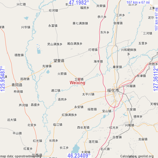
Weixing GPS coordinates[2]
46° 43' 5.88" North, 126° 39' 28.764" East
| Map corner | latitude | longitude |
|---|---|---|
| Upper-left | 47.1982°, | 125.95487° |
| Center: | 46.7183°, | 126.65799° |
| Lower-right: | 46.23409°, | 127.36112° |
| Map W x H: | 107.2×107.2 km | = 66.6×66.6mi |
| max Lat: | 53.31946° ⇑3.7% North |
| Weixing: | 46.7183° |
| min Lat: | ⇓96.3% South 18.22056° |
| min Long | Weixing | max Long |
| 75.07348° | 126.65799° | 134.28917° |
| W 96.2%⇐ | ⇒3.8% E |
Elevation
Elevation of Weixing is 209 m = 686 ft, and this is 275.8 m = 905 ft below average elevation for this country.
| Max E: |
5622 m = 18445 ft | 44.7% |
| Avg. | 484.8 m = 1591 ft | |
| Weixing | 209 m = 686 ft | |
Min E: |
-3 m = -10 ft | 55.3% |
See also: China elevation on elevation.city.
Geographical zone
Weixing is located in North temperate zone (between Tropic of Cancer and the Arctic Circle). Distance of this North polar circle is 2206.6 km =1371.1 mi to North.| Distance of | km | miles | from Weixing |
|---|---|---|---|
| North Pole | 4812.5 | 2990.3 | to North |
| Arctic Circle | 2206.6 | 1371.1 | to North |
| Tropic Cancer | 2588.7 | 1608.5 | to South |
| Equator | 5194.6 | 3227.8 | to South |


Nearby cities:
15 places around Weixing: (largest is in red/bold)
• Dayou
26.7 km =16.6 mi,  109°
109°
• Dengta
22.3 km =13.9 mi,  24°
24°
• Dongfu
27.7 km =17.2 mi,  103°
103°
• Haifeng
17.8 km =11.1 mi,  46°
46°
• Hongqi
25 km =15.5 mi,  195°
195°
• Huojian
12.5 km =7.8 mi,  288°
288°
• Qinjia
27.4 km =17 mi,  71°
71°
• Suihua
27.2 km =16.9 mi, 108°
• Suisheng
22.2 km =13.8 mi,  155°
155°
• Taipingchuan
11.9 km =7.4 mi,  149°
149°
• Tongjiang
17.5 km =10.9 mi,  245°
245°
• Wangkui
18.7 km =11.6 mi,  312°
312°
• Xiangbai
24.5 km =15.2 mi,  353°
353°
• Xinhua
16.3 km =10.1 mi,  120°
120°
• Yong’an
18.7 km =11.6 mi,  180°
180°
Sources, notices
• [Note1] Compared only with cities in China existing in our database
• [Src1] Map data: © OpenStreetMap contributors (CC-BY-SA)
• [Src2] Other city data from geonames.org with taken over terms of usage.
• [Src3] Geographical zone / Annual Mean Temperature by Robert A. Rohde @ Wikipedia
