Baixiang geodata
Baixiang (Heilongjiang) is a seat of a fourth-order administrative division; located in China in Asia/Shanghai (GMT+8) time zone. In our database, there are 1268 cities with bigger population. Compared to other cities in China, 97.4% of cities are located further ↓South; 96% of cities are located further ←West and 51.5% of cities have lower elevation than Baixiang. Note1


Baixiang GPS coordinates[2]
47° 13' 23.088" North, 126° 27' 9.216" East
| Map corner | latitude | longitude |
|---|---|---|
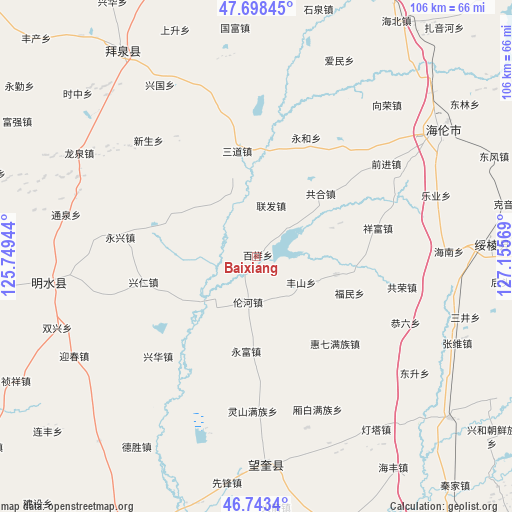
| Upper-left | 47.69845°, | 125.74944° |
| Center: | 47.22308°, | 126.45256° |
| Lower-right: | 46.7434°, | 127.15569° |
| Map W x H: | 106.2×106.2 km | = 66×66mi |
| max Lat: | 53.31946° ⇑2.6% North |
| Baixiang: | 47.22308° |
| min Lat: | ⇓97.4% South 18.22056° |
| min Long | Baixiang | max Long |
| 75.07348° | 126.45256° | 134.28917° |
| W 96%⇐ | ⇒4% E |
Elevation
Elevation of Baixiang is 177 m = 581 ft, and this is 307.8 m = 1010 ft below average elevation for this country.
| Max E: |
5622 m = 18445 ft | 48.5% |
| Avg. | 484.8 m = 1591 ft | |
| Baixiang | 177 m = 581 ft | |
Min E: |
-3 m = -10 ft | 51.5% |
See also: China elevation on elevation.city.
Geographical zone
Baixiang is located in North temperate zone (between Tropic of Cancer and the Arctic Circle). Distance of this North polar circle is 2150.5 km =1336.3 mi to North.| Distance of | km | miles | from Baixiang |
|---|---|---|---|
| North Pole | 4756.3 | 2955.4 | to North |
| Arctic Circle | 2150.5 | 1336.3 | to North |
| Tropic Cancer | 2644.8 | 1643.4 | to South |
| Equator | 5250.7 | 3262.6 | to South |


Nearby cities:
15 places around Baixiang: (largest is in red/bold)
• Fanrong
18.2 km =11.3 mi,  299°
299°
• Fengshan
10.9 km =6.8 mi,  121°
121°
• Fumin
21.1 km =13.1 mi,  111°
111°
• Gonghe
18.6 km =11.6 mi,  45°
45°
• Guangrong
14.6 km =9.1 mi,  316°
316°
• Haixing
16.9 km =10.5 mi,  103°
103°
• Huiqi
24.5 km =15.2 mi,  137°
137°
• Lianfa
10.9 km =6.8 mi,  14°
14°
• Lunhe
9.6 km =6 mi,  190°
190°
• Sandao
22 km =13.7 mi,  349°
349°
• Shuren
18.9 km =11.7 mi,  248°
248°
• Xiangfu
25.5 km =15.8 mi,  76°
76°
• Xingren
24.1 km =15 mi,  257°
257°
• Yongfu
19.8 km =12.3 mi, 186°
• Yonghe
26.6 km =16.5 mi,  22°
22°
Sources, notices
• [Note1] Compared only with cities in China existing in our database
• [Src1] Map data: © OpenStreetMap contributors (CC-BY-SA)
• [Src2] Other city data from geonames.org with taken over terms of usage.
• [Src3] Geographical zone / Annual Mean Temperature by Robert A. Rohde @ Wikipedia
