Xilin Hot geodata
Xilin Hot (Inner Mongolia) is a populated place; located in China in Asia/Shanghai (GMT+8) time zone. With population of 120,965 people, there are 365 cities with bigger population in this country. Compared to other cities in China, 92.7% of cities are located further ↓South; 60.3% of cities are located further ←West and 85% of cities have lower elevation than Xilin Hot. Note1


Xilin Hot GPS coordinates[2]
43° 58' 0.012" North, 116° 1' 59.988" East
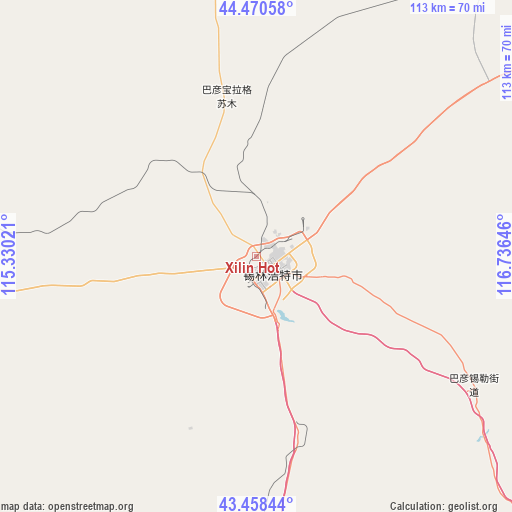
| Map corner | latitude | longitude |
|---|---|---|
| Upper-left | 44.47058°, | 115.33021° |
| Center: | 43.96667°, | 116.03333° |
| Lower-right: | 43.45844°, | 116.73646° |
| Map W x H: | 112.5×112.5 km | = 69.9×69.9mi |
| max Lat: | 53.31946° ⇑7.3% North |
| Xilin Hot: | 43.96667° |
| min Lat: | ⇓92.7% South 18.22056° |
| min Long | Xilin Hot | max Long |
| 75.07348° | 116.03333° | 134.28917° |
| W 60.3%⇐ | ⇒39.7% E |
Elevation
Elevation of Xilin Hot is 982 m = 3222 ft, and this is 497.2 m = 1631 ft above average elevation for this country.
| Max E: |
5622 m = 18445 ft | 15% |
| Xilin Hot | 982 m 3222 ft | |
| Avg. | 484.8 m = 1591 ft | |
Min E: |
-3 m = -10 ft | 85% |
See also: Xilin Hot elevation on elevation.city.
Geographical zone
Xilin Hot is located in North temperate zone (between Tropic of Cancer and the Arctic Circle). Distance of this Northern Tropic circle is 2282.7 km =1418.4 mi to South.| Distance of | km | miles | from Xilin Hot |
|---|---|---|---|
| North Pole | 5118.4 | 3180.4 | to North |
| Arctic Circle | 2512.5 | 1561.2 | to North |
| Tropic Cancer | 2282.7 | 1418.4 | to South |
| Equator | 4888.6 | 3037.6 | to South |


Nearby cities:
15 places around Xilin Hot: (largest is in red/bold)
• Altan Hil
143.5 km =89.2 mi,  342°
342°
• Bala Ga’er Gaole
144.4 km =89.7 mi,  61°
61°
• Bayan Bulag
30.4 km =18.9 mi,  347°
347°
• Bayan Huxu
153.8 km =95.6 mi,  48°
48°
• Bayan Tug
152.4 km =94.7 mi,  313°
313°
• Bieligutai
84.5 km =52.5 mi,  274°
274°
• Jingpeng
143.6 km =89.2 mi,  123°
123°
• Jirin Gol
99.4 km =61.8 mi, 55°
• Linxi
168.3 km =104.6 mi,  107°
107°
• Mandalt
186.2 km =115.7 mi, 265°
• Naran Bulag
169.6 km =105.4 mi,  295°
295°
• Shangdu
190.9 km =118.6 mi,  180°
180°
• Subrag
196.1 km =121.9 mi,  82°
82°
• Uliastai
187 km =116.2 mi,  19°
19°
• Xiritala
4.3 km =2.7 mi,  136°
136°
Sources, notices
• [Note1] Compared only with cities in China existing in our database
• [Src1] Map data: © OpenStreetMap contributors (CC-BY-SA)
• [Src2] Other city data from geonames.org with taken over terms of usage.
• [Src3] Geographical zone / Annual Mean Temperature by Robert A. Rohde @ Wikipedia
