Mandalt geodata
Mandalt (Inner Mongolia) is a seat of a third-order administrative division; located in China in Asia/Shanghai (GMT+8) time zone. In our database, there are 1268 cities with bigger population. Compared to other cities in China, 92.5% of cities are located further ↓South; 53% of cities are located further →East and 86.9% of cities have lower elevation than Mandalt. Note1


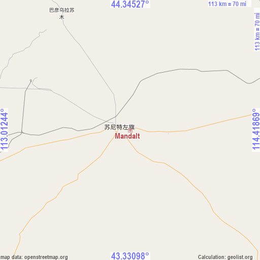
Mandalt GPS coordinates[2]
43° 50' 25.008" North, 113° 42' 56.016" East
| Map corner | latitude | longitude |
|---|---|---|
| Upper-left | 44.34527°, | 113.01244° |
| Center: | 43.84028°, | 113.71556° |
| Lower-right: | 43.33098°, | 114.41869° |
| Map W x H: | 112.8×112.8 km | = 70.1×70.1mi |
| max Lat: | 53.31946° ⇑7.5% North |
| Mandalt: | 43.84028° |
| min Lat: | ⇓92.5% South 18.22056° |
| min Long | Mandalt | max Long |
| 75.07348° | 113.71556° | 134.28917° |
| W 47%⇐ | ⇒53% E |
Elevation
Elevation of Mandalt is 1104 m = 3622 ft, and this is 619.2 m = 2031 ft above average elevation for this country.
| Max E: |
5622 m = 18445 ft | 13.1% |
| Mandalt | 1104 m 3622 ft | |
| Avg. | 484.8 m = 1591 ft | |
Min E: |
-3 m = -10 ft | 86.9% |
See also: China elevation on elevation.city.
Geographical zone
Mandalt is located in North temperate zone (between Tropic of Cancer and the Arctic Circle). Distance of this Northern Tropic circle is 2268.7 km =1409.7 mi to South.| Distance of | km | miles | from Mandalt |
|---|---|---|---|
| North Pole | 5132.5 | 3189.2 | to North |
| Arctic Circle | 2526.6 | 1570 | to North |
| Tropic Cancer | 2268.7 | 1409.7 | to South |
| Equator | 4874.6 | 3028.9 | to South |


Nearby cities:
15 places around Mandalt: (largest is in red/bold)
• Altan Hil
207 km =128.6 mi,  43°
43°
• Bayan Bulag
183.9 km =114.3 mi,  76°
76°
• Bayan Tug
140.8 km =87.5 mi,  31°
31°
• Bieligutai
103.5 km =64.3 mi, 78°
• Changshun
217.9 km =135.4 mi,  174°
174°
• Dalai
104.8 km =65.1 mi,  326°
326°
• Erenhot
141.3 km =87.8 mi,  261°
261°
• Honggor
153.1 km =95.1 mi,  308°
308°
• Ming’antu
200 km =124.3 mi,  148°
148°
• Naran Bulag
93.8 km =58.3 mi,  19°
19°
• Qagan Obo
164.3 km =102.1 mi,  286°
286°
• Saihan Tal
150 km =93.2 mi,  215°
215°
• Xilin Hot
186.2 km =115.7 mi,  85°
85°
• Xin Bulag
178.5 km =110.9 mi,  176°
176°
• Xiritala
189 km =117.4 mi, 86°
Sources, notices
• [Note1] Compared only with cities in China existing in our database
• [Src1] Map data: © OpenStreetMap contributors (CC-BY-SA)
• [Src2] Other city data from geonames.org with taken over terms of usage.
• [Src3] Geographical zone / Annual Mean Temperature by Robert A. Rohde @ Wikipedia
