Tieling geodata
Tieling (Liaoning) is a populated place; located in China in Asia/Shanghai (GMT+8) time zone. With population of 333,907 people, there are 169 cities with bigger population in this country. Compared to other cities in China, 91.2% of cities are located further ↓South; 93.6% of cities are located further ←West and 67.2% of cities have higher elevation than Tieling. Note1


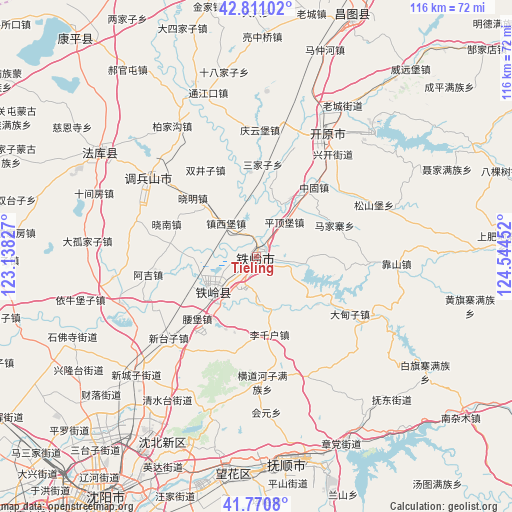
Tieling GPS coordinates[2]
42° 17' 35.016" North, 123° 50' 29.004" East
| Map corner | latitude | longitude |
|---|---|---|
| Upper-left | 42.81102°, | 123.13827° |
| Center: | 42.29306°, | 123.84139° |
| Lower-right: | 41.7708°, | 124.54452° |
| Map W x H: | 115.7×115.7 km | = 71.9×71.9mi |
| max Lat: | 53.31946° ⇑8.8% North |
| Tieling: | 42.29306° |
| min Lat: | ⇓91.2% South 18.22056° |
| min Long | Tieling | max Long |
| 75.07348° | 123.84139° | 134.28917° |
| W 93.6%⇐ | ⇒6.4% E |
Elevation
Elevation of Tieling is 64 m = 210 ft, and this is 420.8 m = 1381 ft below average elevation for this country.
| Max E: |
5622 m = 18445 ft | 67.2% |
| Avg. | 484.8 m = 1591 ft | |
| Tieling | 64 m = 210 ft | |
Min E: |
-3 m = -10 ft | 32.8% |
See also: Tieling elevation on elevation.city.
Geographical zone
Tieling is located in North temperate zone (between Tropic of Cancer and the Arctic Circle). Distance of this Northern Tropic circle is 2096.6 km =1302.8 mi to South.| Distance of | km | miles | from Tieling |
|---|---|---|---|
| North Pole | 5304.5 | 3296.1 | to North |
| Arctic Circle | 2698.6 | 1676.8 | to North |
| Tropic Cancer | 2096.6 | 1302.8 | to South |
| Equator | 4702.5 | 2922 | to South |


Nearby cities:
15 places around Tieling: (largest is in red/bold)
• Dasijiazi
54.1 km =33.6 mi,  341°
341°
• Daxing
55 km =34.2 mi,  0°
0°
• Dongzhou
50.4 km =31.3 mi,  161°
161°
• Fushun
46 km =28.6 mi,  169°
169°
• Guyushu
38.8 km =24.1 mi, 343°
• Hada
43.5 km =27 mi,  145°
145°
• Haoguantun
51.4 km =31.9 mi,  325°
325°
• Hushitai
48 km =29.8 mi,  215°
215°
• Kaiyuan
31.3 km =19.4 mi,  31°
31°
• Mazhonghe
49.2 km =30.6 mi,  17°
17°
• Nianpan
54.9 km =34.1 mi, 162°
• Qiandian
46.3 km =28.8 mi, 163°
• Shibajiazi
42.3 km =26.3 mi,  350°
350°
• Yongfeng
49.8 km =30.9 mi, 0°
• Zhangdang
47 km =29.2 mi, 155°
Sources, notices
• [Note1] Compared only with cities in China existing in our database
• [Src1] Map data: © OpenStreetMap contributors (CC-BY-SA)
• [Src2] Other city data from geonames.org with taken over terms of usage.
• [Src3] Geographical zone / Annual Mean Temperature by Robert A. Rohde @ Wikipedia
