Hushitai geodata
Hushitai (Liaoning) is a populated place; located in China in Asia/Shanghai (GMT+8) time zone. With population of 61,979 people, there are 698 cities with bigger population in this country. Compared to other cities in China, 90.9% of cities are located further ↓South; 93.2% of cities are located further ←West and 66.6% of cities have higher elevation than Hushitai. Note1


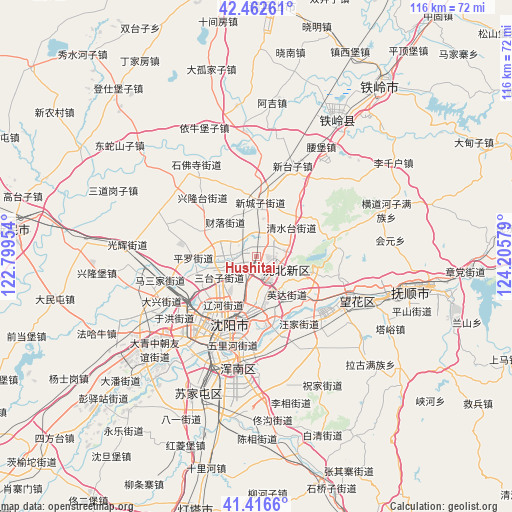
Hushitai GPS coordinates[2]
41° 56' 30.3" North, 123° 30' 9.576" East
| Map corner | latitude | longitude |
|---|---|---|
| Upper-left | 42.46261°, | 122.79954° |
| Center: | 41.94175°, | 123.50266° |
| Lower-right: | 41.4166°, | 124.20579° |
| Map W x H: | 116.3×116.3 km | = 72.3×72.3mi |
| max Lat: | 53.31946° ⇑9.1% North |
| Hushitai: | 41.94175° |
| min Lat: | ⇓90.9% South 18.22056° |
| min Long | Hushitai | max Long |
| 75.07348° | 123.50266° | 134.28917° |
| W 93.2%⇐ | ⇒6.8% E |
Elevation
Elevation of Hushitai is 66 m = 217 ft, and this is 418.8 m = 1374 ft below average elevation for this country.
| Max E: |
5622 m = 18445 ft | 66.6% |
| Avg. | 484.8 m = 1591 ft | |
| Hushitai | 66 m = 217 ft | |
Min E: |
-3 m = -10 ft | 33.4% |
See also: Hushitai elevation on elevation.city.
Geographical zone
Hushitai is located in North temperate zone (between Tropic of Cancer and the Arctic Circle). Distance of this Northern Tropic circle is 2057.6 km =1278.5 mi to South.| Distance of | km | miles | from Hushitai |
|---|---|---|---|
| North Pole | 5343.6 | 3320.4 | to North |
| Arctic Circle | 2737.7 | 1701.1 | to North |
| Tropic Cancer | 2057.6 | 1278.5 | to South |
| Equator | 4663.5 | 2897.8 | to South |


Nearby cities:
15 places around Hushitai: (largest is in red/bold)
• Dongling
15.4 km =9.6 mi,  156°
156°
• Dongzhou
45.2 km =28.1 mi,  100°
100°
• Fushun
37 km =23 mi, 99°
• Hada
52.9 km =32.9 mi,  86°
86°
• Jiubing
60.4 km =37.5 mi,  123°
123°
• Lanshan
51.5 km =32 mi,  107°
107°
• Nianpan
46.3 km =28.8 mi, 106°
• Qiandian
41.7 km =25.9 mi, 97°
• Shangma
56.5 km =35.1 mi, 108°
• Shenyang
17.6 km =10.9 mi,  199°
199°
• Sujiatun
34.2 km =21.3 mi, 203°
• Tieling
48 km =29.8 mi,  35°
35°
• Xinmin
56.3 km =35 mi,  275°
275°
• Zhangdang
47.5 km =29.5 mi, 94°
• Zhangdian
46.7 km =29 mi, 107°
Sources, notices
• [Note1] Compared only with cities in China existing in our database
• [Src1] Map data: © OpenStreetMap contributors (CC-BY-SA)
• [Src2] Other city data from geonames.org with taken over terms of usage.
• [Src3] Geographical zone / Annual Mean Temperature by Robert A. Rohde @ Wikipedia
