Shalan geodata
Shalan (Heilongjiang) is a seat of a fourth-order administrative division; located in China in Asia/Shanghai (GMT+8) time zone. In our database, there are 1268 cities with bigger population. Compared to other cities in China, 93% of cities are located further ↓South; 98.4% of cities are located further ←West and 63.3% of cities have lower elevation than Shalan. Note1


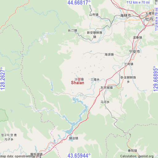
Shalan GPS coordinates[2]
44° 9' 57.456" North, 128° 57' 56.952" East
| Map corner | latitude | longitude |
|---|---|---|
| Upper-left | 44.66817°, | 128.2627° |
| Center: | 44.16596°, | 128.96582° |
| Lower-right: | 43.65944°, | 129.66895° |
| Map W x H: | 112.2×112.2 km | = 69.7×69.7mi |
| max Lat: | 53.31946° ⇑7% North |
| Shalan: | 44.16596° |
| min Lat: | ⇓93% South 18.22056° |
| min Long | Shalan | max Long |
| 75.07348° | 128.96582° | 134.28917° |
| W 98.4%⇐ | ⇒1.6% E |
Elevation
Elevation of Shalan is 300 m = 984 ft, and this is 184.8 m = 606 ft below average elevation for this country.
| Max E: |
5622 m = 18445 ft | 36.7% |
| Avg. | 484.8 m = 1591 ft | |
| Shalan | 300 m = 984 ft | |
Min E: |
-3 m = -10 ft | 63.3% |
See also: China elevation on elevation.city.
Geographical zone
Shalan is located in North temperate zone (between Tropic of Cancer and the Arctic Circle). Distance of this Northern Tropic circle is 2304.9 km =1432.2 mi to South.| Distance of | km | miles | from Shalan |
|---|---|---|---|
| North Pole | 5096.3 | 3166.7 | to North |
| Arctic Circle | 2490.4 | 1547.5 | to North |
| Tropic Cancer | 2304.9 | 1432.2 | to South |
| Equator | 4910.8 | 3051.4 | to South |


Nearby cities:
15 places around Shalan: (largest is in red/bold)
• Bohai
15.7 km =9.8 mi,  110°
110°
• Changting
33.9 km =21.1 mi,  353°
353°
• Dongjingcheng
20.3 km =12.6 mi, 106°
• Hailang
27.7 km =17.2 mi,  50°
50°
• Jiujie
26.5 km =16.5 mi,  21°
21°
• Langang
36.8 km =22.9 mi,  72°
72°
• Mahe
22.2 km =13.8 mi,  127°
127°
• Ning’an
44.4 km =27.6 mi,  63°
63°
• Ping’an
26.6 km =16.5 mi,  79°
79°
• Sanling
11.4 km =7.1 mi,  89°
89°
• Shihe
44.9 km =27.9 mi,  31°
31°
• Shiyan
29.5 km =18.3 mi, 87°
• Wolong
35.1 km =21.8 mi, 90°
• Xinghua
16.9 km =10.5 mi, 68°
• Xin’an
30.9 km =19.2 mi, 23°
Sources, notices
• [Note1] Compared only with cities in China existing in our database
• [Src1] Map data: © OpenStreetMap contributors (CC-BY-SA)
• [Src2] Other city data from geonames.org with taken over terms of usage.
• [Src3] Geographical zone / Annual Mean Temperature by Robert A. Rohde @ Wikipedia
