Mahe geodata
Mahe (Heilongjiang) is a seat of a fourth-order administrative division; located in China in Asia/Shanghai (GMT+8) time zone. In our database, there are 1268 cities with bigger population. Compared to other cities in China, 92.8% of cities are located further ↓South; 98.5% of cities are located further ←West and 63.6% of cities have lower elevation than Mahe. Note1


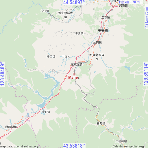
Mahe GPS coordinates[2]
44° 2' 44.628" North, 129° 11' 16.836" East
| Map corner | latitude | longitude |
|---|---|---|
| Upper-left | 44.54897°, | 128.48489° |
| Center: | 44.04573°, | 129.18801° |
| Lower-right: | 43.53818°, | 129.89114° |
| Map W x H: | 112.4×112.4 km | = 69.8×69.8mi |
| max Lat: | 53.31946° ⇑7.2% North |
| Mahe: | 44.04573° |
| min Lat: | ⇓92.8% South 18.22056° |
| min Long | Mahe | max Long |
| 75.07348° | 129.18801° | 134.28917° |
| W 98.5%⇐ | ⇒1.5% E |
Elevation
Elevation of Mahe is 305 m = 1001 ft, and this is 179.8 m = 590 ft below average elevation for this country.
| Max E: |
5622 m = 18445 ft | 36.4% |
| Avg. | 484.8 m = 1591 ft | |
| Mahe | 305 m = 1001 ft | |
Min E: |
-3 m = -10 ft | 63.6% |
See also: China elevation on elevation.city.
Geographical zone
Mahe is located in North temperate zone (between Tropic of Cancer and the Arctic Circle). Distance of this Northern Tropic circle is 2291.5 km =1423.9 mi to South.| Distance of | km | miles | from Mahe |
|---|---|---|---|
| North Pole | 5109.6 | 3175 | to North |
| Arctic Circle | 2503.7 | 1555.7 | to North |
| Tropic Cancer | 2291.5 | 1423.9 | to South |
| Equator | 4897.4 | 3043.1 | to South |


Nearby cities:
15 places around Mahe: (largest is in red/bold)
• Bohai
8.5 km =5.3 mi,  338°
338°
• Chunyang
42 km =26.1 mi,  152°
152°
• Dongjingcheng
7.8 km =4.8 mi,  12°
12°
• Fanjia
43.3 km =26.9 mi,  31°
31°
• Hailang
31.3 km =19.4 mi, 6°
• Jiujie
39 km =24.2 mi,  347°
347°
• Langang
29.8 km =18.5 mi,  35°
35°
• Ning’an
39.9 km =24.8 mi, 33°
• Ping’an
19.9 km =12.4 mi, 25°
• Sanling
14.8 km =9.2 mi,  334°
334°
• Shalan
22.2 km =13.8 mi,  307°
307°
• Shiyan
18.7 km =11.6 mi, 38°
• Wolong
21.9 km =13.6 mi,  52°
52°
• Xinghua
19.6 km =12.2 mi, 354°
• Xin’an
42.1 km =26.2 mi, 352°
Sources, notices
• [Note1] Compared only with cities in China existing in our database
• [Src1] Map data: © OpenStreetMap contributors (CC-BY-SA)
• [Src2] Other city data from geonames.org with taken over terms of usage.
• [Src3] Geographical zone / Annual Mean Temperature by Robert A. Rohde @ Wikipedia
