Zhangjiakou Shi Xuanhua Qu geodata
Zhangjiakou Shi Xuanhua Qu (Hebei) is a seat of a third-order administrative division; located in China in Asia/Shanghai (GMT+8) time zone. With population of 373,422 people, there are 158 cities with bigger population in this country. Compared to other cities in China, 88.3% of cities are located further ↓South; 54.6% of cities are located further ←West and 77.9% of cities have lower elevation than Zhangjiakou Shi Xuanhua Qu. Note1
Current local time in Zhangjiakou Shi Xuanhua Qu:
04:55 PM, TuesdayDifference from your time zone: hours


Zhangjiakou Shi Xuanhua Qu GPS coordinates[2]
40° 36' 37.008" North, 115° 2' 40.992" East
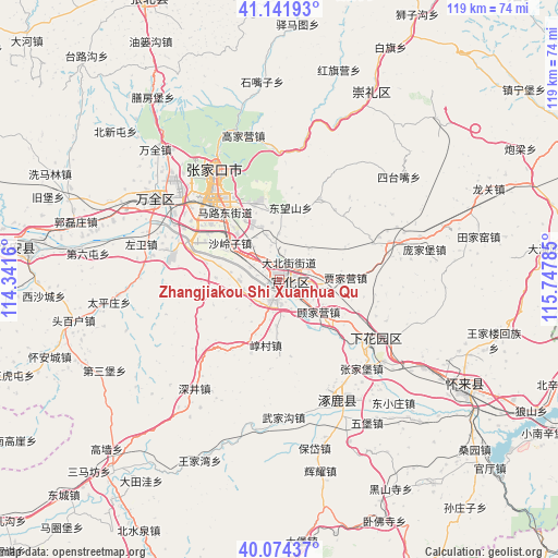
| Map corner | latitude | longitude |
|---|---|---|
| Upper-left | 41.14193°, | 114.3416° |
| Center: | 40.61028°, | 115.04472° |
| Lower-right: | 40.07437°, | 115.74785° |
| Map W x H: | 118.7×118.7 km | = 73.8×73.8mi |
| max Lat: | 53.31946° ⇑11.7% North |
| Zhangjiakou Shi Xuanhua Qu: | 40.61028° |
| min Lat: | ⇓88.3% South 18.22056° |
| min Long | Zhangjiakou Shi | max Long |
| 75.07348° | 115.04472° | 134.28917° |
| W 54.6%⇐ | ⇒45.4% E |
Elevation
Elevation of Zhangjiakou Shi Xuanhua Qu is 610 m = 2001 ft, and this is 125.2 m = 411 ft above average elevation for this country.
| Max E: |
5622 m = 18445 ft | 22.1% |
| Zhangjiakou Shi Xuanhua Qu | 610 m 2001 ft | |
| Avg. | 484.8 m = 1591 ft | |
Min E: |
-3 m = -10 ft | 77.9% |
See also: Zhangjiakou Shi Xuanhua Qu elevation on elevation.city.
Geographical zone
Zhangjiakou Shi Xuanhua Qu is located in North temperate zone (between Tropic of Cancer and the Arctic Circle). Distance of this Northern Tropic circle is 1909.5 km =1186.5 mi to South.| Distance of | km | miles | from Zhangjiakou Shi Xuanhua Qu |
|---|---|---|---|
| North Pole | 5491.6 | 3412.3 | to North |
| Arctic Circle | 2885.7 | 1793.1 | to North |
| Tropic Cancer | 1909.5 | 1186.5 | to South |
| Equator | 4515.4 | 2805.7 | to South |


Nearby cities:
15 places around Zhangjiakou Shi Xuanhua Qu: (largest is in red/bold)
• Badaling
84.1 km =52.3 mi,  109°
109°
• Chaigoubu
53.8 km =33.4 mi,  276°
276°
• Chengzhen
23.8 km =14.8 mi,  127°
127°
• Chicheng
72.3 km =44.9 mi,  66°
66°
• Kangzhuang
76.3 km =47.4 mi, 109°
• Kongjiazhuang
31.2 km =19.4 mi,  300°
300°
• Shacheng
46.4 km =28.8 mi,  121°
121°
• Taohua
61.3 km =38.1 mi,  182°
182°
• Xibali
31 km =19.3 mi, 124°
• Xiwanzi
44.5 km =27.7 mi,  25°
25°
• Yanjiatai
80.7 km =50.1 mi,  147°
147°
• Yanqing
80.1 km =49.8 mi,  101°
101°
• Zhangbei
66.6 km =41.4 mi,  334°
334°
• Zhangjiakou
26.2 km =16.3 mi, 327°
• Zhuolu
30.4 km =18.9 mi, 151°
Sources, notices
• [Note1] Compared only with cities in China existing in our database
• [Src1] Map data: © OpenStreetMap contributors (CC-BY-SA)
• [Src2] Other city data from geonames.org with taken over terms of usage.
• [Src3] Geographical zone / Annual Mean Temperature by Robert A. Rohde @ Wikipedia
