Bamiantong geodata
Bamiantong (Heilongjiang) is a seat of a third-order administrative division; located in China in Asia/Shanghai (GMT+8) time zone. With population of 66,170 people, there are 650 cities with bigger population in this country. Compared to other cities in China, 93.8% of cities are located further ↓South; 99.6% of cities are located further ←West and 60.4% of cities have lower elevation than Bamiantong. Note1


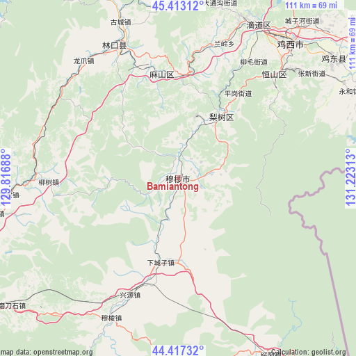
Bamiantong GPS coordinates[2]
44° 55' 2.568" North, 130° 31' 12" East
| Map corner | latitude | longitude |
|---|---|---|
| Upper-left | 45.41312°, | 129.81688° |
| Center: | 44.91738°, | 130.52° |
| Lower-right: | 44.41732°, | 131.22313° |
| Map W x H: | 110.7×110.7 km | = 68.8×68.8mi |
| max Lat: | 53.31946° ⇑6.2% North |
| Bamiantong: | 44.91738° |
| min Lat: | ⇓93.8% South 18.22056° |
| min Long | Bamiantong | max Long |
| 75.07348° | 130.52° | 134.28917° |
| W 99.6%⇐ | ⇒0.40000000000001% E |
Elevation
Elevation of Bamiantong is 264 m = 866 ft, and this is 220.8 m = 724 ft below average elevation for this country.
| Max E: |
5622 m = 18445 ft | 39.6% |
| Avg. | 484.8 m = 1591 ft | |
| Bamiantong | 264 m = 866 ft | |
Min E: |
-3 m = -10 ft | 60.4% |
See also: Bamiantong elevation on elevation.city.
Geographical zone
Bamiantong is located in North temperate zone (between Tropic of Cancer and the Arctic Circle). Distance of this Northern Tropic circle is 2388.4 km =1484.1 mi to South.| Distance of | km | miles | from Bamiantong |
|---|---|---|---|
| North Pole | 5012.7 | 3114.7 | to North |
| Arctic Circle | 2406.8 | 1495.5 | to North |
| Tropic Cancer | 2388.4 | 1484.1 | to South |
| Equator | 4994.3 | 3103.3 | to South |


Nearby cities:
15 places around Bamiantong: (largest is in red/bold)
• Fendou
44.5 km =27.7 mi,  42°
42°
• Fulu
5.2 km =3.2 mi,  67°
67°
• Hexi
3.1 km =1.9 mi,  289°
289°
• Hongqi
45.7 km =28.4 mi, 44°
• Kuishan
35.9 km =22.3 mi,  344°
344°
• Lanling
44.3 km =27.5 mi,  18°
18°
• Linkou
45.7 km =28.4 mi,  333°
333°
• Lishu
23.4 km =14.5 mi, 35°
• Liushu
40.3 km =25 mi,  268°
268°
• Longzhua
47.2 km =29.3 mi,  321°
321°
• Maqiaohe
25.2 km =15.7 mi,  177°
177°
• Mashan
32 km =19.9 mi,  0°
0°
• Muleng
49 km =30.4 mi,  205°
205°
• Xiachengzi
26.3 km =16.3 mi,  191°
191°
• Xingyuan
39.2 km =24.4 mi,  202°
202°
Sources, notices
• [Note1] Compared only with cities in China existing in our database
• [Src1] Map data: © OpenStreetMap contributors (CC-BY-SA)
• [Src2] Other city data from geonames.org with taken over terms of usage.
• [Src3] Geographical zone / Annual Mean Temperature by Robert A. Rohde @ Wikipedia
