Gongzhuling geodata
Gongzhuling (Jilin) is a populated place; located in China in Asia/Shanghai (GMT+8) time zone. With population of 140,909 people, there are 314 cities with bigger population in this country. Compared to other cities in China, 92.3% of cities are located further ↓South; 94.6% of cities are located further ←West and 55.5% of cities have lower elevation than Gongzhuling. Note1


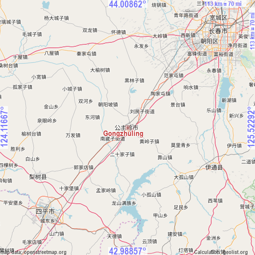
Gongzhuling GPS coordinates[2]
43° 30' 2.7" North, 124° 49' 11.244" East
| Map corner | latitude | longitude |
|---|---|---|
| Upper-left | 44.00862°, | 124.11667° |
| Center: | 43.50075°, | 124.81979° |
| Lower-right: | 42.98857°, | 125.52292° |
| Map W x H: | 113.4×113.4 km | = 70.5×70.5mi |
| max Lat: | 53.31946° ⇑7.7% North |
| Gongzhuling: | 43.50075° |
| min Lat: | ⇓92.3% South 18.22056° |
| min Long | Gongzhuling | max Long |
| 75.07348° | 124.81979° | 134.28917° |
| W 94.6%⇐ | ⇒5.4% E |
Elevation
Elevation of Gongzhuling is 211 m = 692 ft, and this is 273.8 m = 898 ft below average elevation for this country.
| Max E: |
5622 m = 18445 ft | 44.5% |
| Avg. | 484.8 m = 1591 ft | |
| Gongzhuling | 211 m = 692 ft | |
Min E: |
-3 m = -10 ft | 55.5% |
See also: Gongzhuling elevation on elevation.city.
Geographical zone
Gongzhuling is located in North temperate zone (between Tropic of Cancer and the Arctic Circle). Distance of this Northern Tropic circle is 2230.9 km =1386.2 mi to South.| Distance of | km | miles | from Gongzhuling |
|---|---|---|---|
| North Pole | 5170.2 | 3212.6 | to North |
| Arctic Circle | 2564.3 | 1593.4 | to North |
| Tropic Cancer | 2230.9 | 1386.2 | to South |
| Equator | 4836.8 | 3005.4 | to South |


Nearby cities:
15 places around Gongzhuling: (largest is in red/bold)
• Baiquan
69.3 km =43.1 mi,  170°
170°
• Bamiancheng
70.9 km =44.1 mi,  241°
241°
• Changchun
58.4 km =36.3 mi,  43°
43°
• Fujia
85 km =52.8 mi,  253°
253°
• Liaoyuan
71.2 km =44.2 mi,  158°
158°
• Lishu
45.3 km =28.1 mi, 241°
• Maojiadian
66.5 km =41.3 mi,  219°
219°
• Qiujia
74 km =46 mi,  234°
234°
• Quangou
57.4 km =35.7 mi, 231°
• Qujiadian
78.4 km =48.7 mi, 246°
• Shuangyang
68.9 km =42.8 mi,  87°
87°
• Siping
52 km =32.3 mi, 223°
• Xia’ertai
74.8 km =46.5 mi,  214°
214°
• Xinglongshan
72.5 km =45 mi,  45°
45°
• Yitong
43.2 km =26.8 mi,  116°
116°
Sources, notices
• [Note1] Compared only with cities in China existing in our database
• [Src1] Map data: © OpenStreetMap contributors (CC-BY-SA)
• [Src2] Other city data from geonames.org with taken over terms of usage.
• [Src3] Geographical zone / Annual Mean Temperature by Robert A. Rohde @ Wikipedia
