Jining geodata
Jining (Inner Mongolia) is a populated place; located in China in Asia/Shanghai (GMT+8) time zone. With population of 258,757 people, there are 195 cities with bigger population in this country. Compared to other cities in China, 89.3% of cities are located further ↓South; 56.9% of cities are located further →East and 90.5% of cities have lower elevation than Jining. Note1


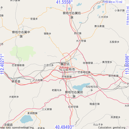
Jining GPS coordinates[2]
41° 1' 39" North, 113° 6' 20.988" East
| Map corner | latitude | longitude |
|---|---|---|
| Upper-left | 41.5558°, | 112.40271° |
| Center: | 41.0275°, | 113.10583° |
| Lower-right: | 40.49493°, | 113.80896° |
| Map W x H: | 118×118 km | = 73.3×73.3mi |
| max Lat: | 53.31946° ⇑10.7% North |
| Jining: | 41.0275° |
| min Lat: | ⇓89.3% South 18.22056° |
| min Long | Jining | max Long |
| 75.07348° | 113.10583° | 134.28917° |
| W 43.1%⇐ | ⇒56.9% E |
Elevation
Elevation of Jining is 1409 m = 4623 ft, and this is 924.2 m = 3032 ft above average elevation for this country.
| Max E: |
5622 m = 18445 ft | 9.5% |
| Jining | 1409 m 4623 ft | |
| Avg. | 484.8 m = 1591 ft | |
Min E: |
-3 m = -10 ft | 90.5% |
See also: Jining elevation on elevation.city.
Geographical zone
Jining is located in North temperate zone (between Tropic of Cancer and the Arctic Circle). Distance of this Northern Tropic circle is 1955.9 km =1215.3 mi to South.| Distance of | km | miles | from Jining |
|---|---|---|---|
| North Pole | 5445.2 | 3383.5 | to North |
| Arctic Circle | 2839.3 | 1764.3 | to North |
| Tropic Cancer | 1955.9 | 1215.3 | to South |
| Equator | 4561.8 | 2834.6 | to South |


Nearby cities:
15 places around Jining: (largest is in red/bold)
• Baiyin Chagan
47.8 km =29.7 mi,  7°
7°
• Benhong
31.5 km =19.6 mi,  21°
21°
• Daliuhao
26.9 km =16.7 mi,  35°
35°
• Hayan Hudong
49.4 km =30.7 mi, 19°
• Hobor
48.4 km =30.1 mi,  304°
304°
• Hongpan
50.2 km =31.2 mi,  326°
326°
• Jinpen
52.8 km =32.8 mi,  271°
271°
• Sandaogou
54.7 km =34 mi,  315°
315°
• Shengli
25 km =15.5 mi,  305°
305°
• Shimenkou
41.7 km =25.9 mi, 23°
• Shiyaogou
29.1 km =18.1 mi,  354°
354°
• Togrog Ul
28 km =17.4 mi,  162°
162°
• Xilei
32.4 km =20.1 mi, 331°
• Yuanshanzi
44.5 km =27.7 mi, 312°
• Zhuozishan
48 km =29.8 mi,  252°
252°
Sources, notices
• [Note1] Compared only with cities in China existing in our database
• [Src1] Map data: © OpenStreetMap contributors (CC-BY-SA)
• [Src2] Other city data from geonames.org with taken over terms of usage.
• [Src3] Geographical zone / Annual Mean Temperature by Robert A. Rohde @ Wikipedia
