Jinhe geodata
Jinhe (Inner Mongolia) is a seat of a fourth-order administrative division; located in China in Asia/Shanghai (GMT+8) time zone. In our database, there are 1268 cities with bigger population. Compared to other cities in China, 99.8% of cities are located further ↓South; 90% of cities are located further ←West and 81.9% of cities have lower elevation than Jinhe. Note1


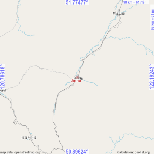
Jinhe GPS coordinates[2]
51° 20' 15.396" North, 121° 29' 21.48" East
| Map corner | latitude | longitude |
|---|---|---|
| Upper-left | 51.77477°, | 120.78618° |
| Center: | 51.33761°, | 121.4893° |
| Lower-right: | 50.89624°, | 122.19243° |
| Map W x H: | 97.7×97.7 km | = 60.7×60.7mi |
| max Lat: | 53.31946° ⇑0.2% North |
| Jinhe: | 51.33761° |
| min Lat: | ⇓99.8% South 18.22056° |
| min Long | Jinhe | max Long |
| 75.07348° | 121.4893° | 134.28917° |
| W 90%⇐ | ⇒10% E |
Elevation
Elevation of Jinhe is 786 m = 2579 ft, and this is 301.2 m = 988 ft above average elevation for this country.
| Max E: |
5622 m = 18445 ft | 18.1% |
| Jinhe | 786 m 2579 ft | |
| Avg. | 484.8 m = 1591 ft | |
Min E: |
-3 m = -10 ft | 81.9% |
See also: China elevation on elevation.city.
Geographical zone
Jinhe is located in North temperate zone (between Tropic of Cancer and the Arctic Circle). Distance of this North polar circle is 1693 km =1052 mi to North.| Distance of | km | miles | from Jinhe |
|---|---|---|---|
| North Pole | 4298.9 | 2671.2 | to North |
| Arctic Circle | 1693 | 1052 | to North |
| Tropic Cancer | 3102.3 | 1927.7 | to South |
| Equator | 5708.2 | 3546.9 | to South |


Nearby cities:
15 places around Jinhe: (largest is in red/bold)
• Alongshan
47.8 km =29.7 mi,  33°
33°
• Aoluguya Ewenke Minzu
101.7 km =63.2 mi,  23°
23°
• Derbur
48.8 km =30.3 mi,  218°
218°
• Ganhe
136.2 km =84.6 mi,  124°
124°
• Genhe
61.7 km =38.3 mi,  178°
178°
• Haolibao
67 km =41.6 mi, 181°
• Keyihe
104.9 km =65.2 mi,  137°
137°
• Mangui
87.8 km =54.6 mi, 26°
• Mo’er Daoga
50.7 km =31.5 mi,  260°
260°
• Niu’erhe
30.2 km =18.8 mi,  36°
36°
• Qiqian
106.6 km =66.2 mi,  332°
332°
• Shiwei
110.4 km =68.6 mi,  269°
269°
• Tulihe
95.8 km =59.5 mi,  172°
172°
• Xiniqi
106.9 km =66.4 mi, 172°
• Yitulihe
78.3 km =48.7 mi, 175°
Sources, notices
• [Note1] Compared only with cities in China existing in our database
• [Src1] Map data: © OpenStreetMap contributors (CC-BY-SA)
• [Src2] Other city data from geonames.org with taken over terms of usage.
• [Src3] Geographical zone / Annual Mean Temperature by Robert A. Rohde @ Wikipedia
