Keyihe geodata
Keyihe (Inner Mongolia) is a seat of a fourth-order administrative division; located in China in Asia/Shanghai (GMT+8) time zone. In our database, there are 1268 cities with bigger population. Compared to other cities in China, 99.7% of cities are located further ↓South; 92.1% of cities are located further ←West and 79.7% of cities have lower elevation than Keyihe. Note1


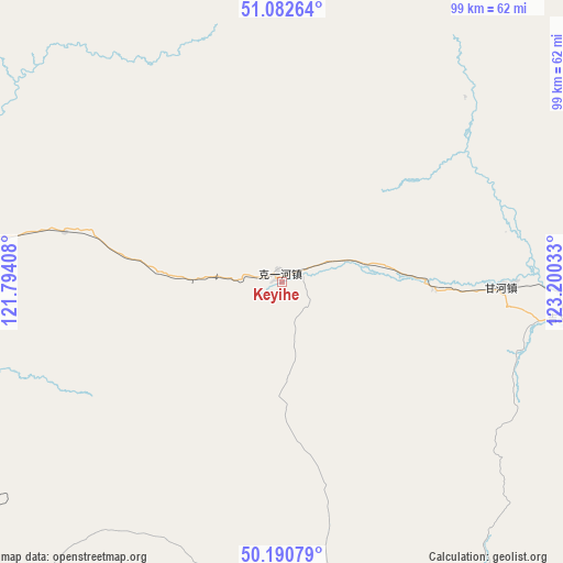
Keyihe GPS coordinates[2]
50° 38' 19.788" North, 122° 29' 49.92" East
| Map corner | latitude | longitude |
|---|---|---|
| Upper-left | 51.08264°, | 121.79408° |
| Center: | 50.63883°, | 122.4972° |
| Lower-right: | 50.19079°, | 123.20033° |
| Map W x H: | 99.2×99.2 km | = 61.6×61.6mi |
| max Lat: | 53.31946° ⇑0.3% North |
| Keyihe: | 50.63883° |
| min Lat: | ⇓99.7% South 18.22056° |
| min Long | Keyihe | max Long |
| 75.07348° | 122.4972° | 134.28917° |
| W 92.1%⇐ | ⇒7.9% E |
Elevation
Elevation of Keyihe is 683 m = 2241 ft, and this is 198.2 m = 650 ft above average elevation for this country.
| Max E: |
5622 m = 18445 ft | 20.3% |
| Keyihe | 683 m 2241 ft | |
| Avg. | 484.8 m = 1591 ft | |
Min E: |
-3 m = -10 ft | 79.7% |
See also: China elevation on elevation.city.
Geographical zone
Keyihe is located in North temperate zone (between Tropic of Cancer and the Arctic Circle). Distance of this North polar circle is 1770.7 km =1100.3 mi to North.| Distance of | km | miles | from Keyihe |
|---|---|---|---|
| North Pole | 4376.6 | 2719.5 | to North |
| Arctic Circle | 1770.7 | 1100.3 | to North |
| Tropic Cancer | 3024.6 | 1879.4 | to South |
| Equator | 5630.5 | 3498.6 | to South |


Nearby cities:
15 places around Keyihe: (largest is in red/bold)
• Derbur
108.4 km =67.4 mi,  291°
291°
• Ganhe
42.5 km =26.4 mi,  88°
88°
• Genhe
70.9 km =44.1 mi,  283°
283°
• Haolibao
73.2 km =45.5 mi, 278°
• Jiagedaqi
117.1 km =72.8 mi,  102°
102°
• Jinhe
104.9 km =65.2 mi,  317°
317°
• Jiwen
49.1 km =30.5 mi, 98°
• Kudu’er
92.3 km =57.4 mi,  222°
222°
• Niu’erhe
114.8 km =71.3 mi,  332°
332°
• Oroqen Zizhiqi
86.4 km =53.7 mi, 95°
• Tulihe
60.6 km =37.7 mi,  253°
253°
• Tuozaminnutuke
68.4 km =42.5 mi,  141°
141°
• Xiniqi
63.2 km =39.3 mi,  243°
243°
• Yitulihe
65.6 km =40.8 mi,  269°
269°
• Yuanlin
115.1 km =71.5 mi, 223°
Sources, notices
• [Note1] Compared only with cities in China existing in our database
• [Src1] Map data: © OpenStreetMap contributors (CC-BY-SA)
• [Src2] Other city data from geonames.org with taken over terms of usage.
• [Src3] Geographical zone / Annual Mean Temperature by Robert A. Rohde @ Wikipedia
