Hulan geodata
Hulan (Heilongjiang) is a populated place; located in China in Asia/Shanghai (GMT+8) time zone. With population of 109,104 people, there are 402 cities with bigger population in this country. Compared to other cities in China, 95% of cities are located further ↓South; 96.1% of cities are located further ←West and 55.5% of cities have higher elevation than Hulan. Note1


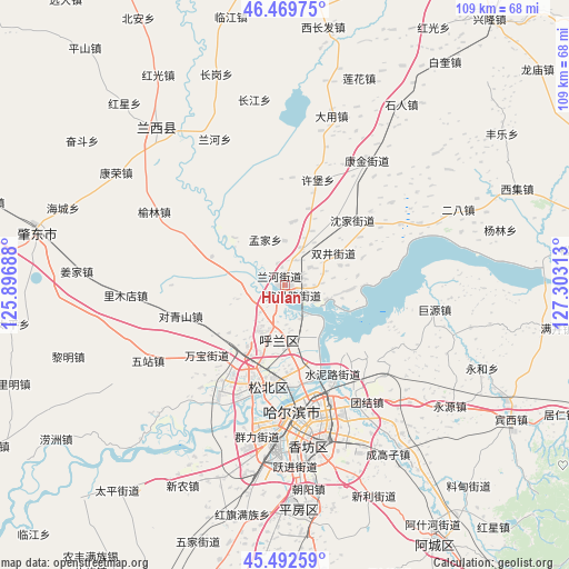
Hulan GPS coordinates[2]
45° 58' 59.988" North, 126° 36' 0" East
| Map corner | latitude | longitude |
|---|---|---|
| Upper-left | 46.46975°, | 125.89688° |
| Center: | 45.98333°, | 126.6° |
| Lower-right: | 45.49259°, | 127.30313° |
| Map W x H: | 108.7×108.6 km | = 67.5×67.5mi |
| max Lat: | 53.31946° ⇑5% North |
| Hulan: | 45.98333° |
| min Lat: | ⇓95% South 18.22056° |
| min Long | Hulan | max Long |
| 75.07348° | 126.6° | 134.28917° |
| W 96.1%⇐ | ⇒3.9% E |
Elevation
Elevation of Hulan is 128 m = 420 ft, and this is 356.8 m = 1171 ft below average elevation for this country.
| Max E: |
5622 m = 18445 ft | 55.5% |
| Avg. | 484.8 m = 1591 ft | |
| Hulan | 128 m = 420 ft | |
Min E: |
-3 m = -10 ft | 44.5% |
See also: Hulan elevation on elevation.city.
Geographical zone
Hulan is located in North temperate zone (between Tropic of Cancer and the Arctic Circle). Distance of this North polar circle is 2288.3 km =1421.9 mi to North.| Distance of | km | miles | from Hulan |
|---|---|---|---|
| North Pole | 4894.2 | 3041.1 | to North |
| Arctic Circle | 2288.3 | 1421.9 | to North |
| Tropic Cancer | 2506.9 | 1557.7 | to South |
| Equator | 5112.9 | 3177 | to South |


Nearby cities:
15 places around Hulan: (largest is in red/bold)
• Changjiang
35.8 km =22.2 mi,  350°
350°
• Changling
7.7 km =4.8 mi,  23°
23°
• Dayong
34.6 km =21.5 mi,  14°
14°
• Fangtai
28.3 km =17.6 mi,  65°
65°
• Harbin
26.2 km =16.3 mi,  171°
171°
• Juyuan
29.1 km =18.1 mi,  99°
99°
• Kangjin
28.5 km =17.7 mi,  33°
33°
• Kangrong
35.7 km =22.2 mi,  310°
310°
• Lanhe
28.3 km =17.6 mi,  334°
334°
• Mengjia
9.3 km =5.8 mi,  336°
336°
• Shenjia
17.7 km =11 mi,  46°
46°
• Shuangjing
11.2 km =7 mi,  57°
57°
• Xiangyang
35.8 km =22.2 mi,  135°
135°
• Xubao
20.9 km =13 mi, 16°
• Yulin
28.6 km =17.8 mi,  299°
299°
Sources, notices
• [Note1] Compared only with cities in China existing in our database
• [Src1] Map data: © OpenStreetMap contributors (CC-BY-SA)
• [Src2] Other city data from geonames.org with taken over terms of usage.
• [Src3] Geographical zone / Annual Mean Temperature by Robert A. Rohde @ Wikipedia
