Huangnihe geodata
Huangnihe (Jilin) is a populated place; located in China in Asia/Shanghai (GMT+8) time zone. With population of 54,959 people, there are 792 cities with bigger population in this country. Compared to other cities in China, 92.4% of cities are located further ↓South; 97.9% of cities are located further ←West and 73.6% of cities have lower elevation than Huangnihe. Note1


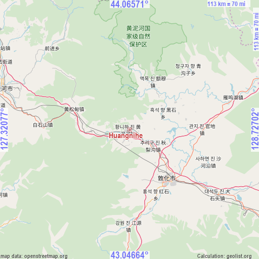
Huangnihe GPS coordinates[2]
43° 33' 29.988" North, 128° 1' 26.004" East
| Map corner | latitude | longitude |
|---|---|---|
| Upper-left | 44.06571°, | 127.32077° |
| Center: | 43.55833°, | 128.02389° |
| Lower-right: | 43.04664°, | 128.72702° |
| Map W x H: | 113.3×113.3 km | = 70.4×70.4mi |
| max Lat: | 53.31946° ⇑7.6% North |
| Huangnihe: | 43.55833° |
| min Lat: | ⇓92.4% South 18.22056° |
| min Long | Huangnihe | max Long |
| 75.07348° | 128.02389° | 134.28917° |
| W 97.9%⇐ | ⇒2.1% E |
Elevation
Elevation of Huangnihe is 490 m = 1608 ft, and this is 5.2 m = 17 ft above average elevation for this country.
| Max E: |
5622 m = 18445 ft | 26.4% |
| Huangnihe | 490 m 1608 ft | |
| Avg. | 484.8 m = 1591 ft | |
Min E: |
-3 m = -10 ft | 73.6% |
See also: Huangnihe elevation on elevation.city.
Geographical zone
Huangnihe is located in North temperate zone (between Tropic of Cancer and the Arctic Circle). Distance of this Northern Tropic circle is 2237.3 km =1390.2 mi to South.| Distance of | km | miles | from Huangnihe |
|---|---|---|---|
| North Pole | 5163.8 | 3208.6 | to North |
| Arctic Circle | 2557.9 | 1589.4 | to North |
| Tropic Cancer | 2237.3 | 1390.2 | to South |
| Equator | 4843.2 | 3009.4 | to South |


Nearby cities:
15 places around Huangnihe: (largest is in red/bold)
• Baishishan
36.9 km =22.9 mi,  274°
274°
• Baishuitan
90.7 km =56.4 mi,  191°
191°
• Changxing
84.9 km =52.8 mi,  119°
119°
• Dadianzi
80 km =49.7 mi,  162°
162°
• Dapuchaihe
75.5 km =46.9 mi,  179°
179°
• Dashitou
48.3 km =30 mi,  125°
125°
• Dunhua
27.2 km =16.9 mi,  139°
139°
• Erdaocha
88.3 km =54.9 mi,  209°
209°
• Erdaodianzi
85 km =52.8 mi,  237°
237°
• Laojinchang
90.5 km =56.2 mi,  216°
216°
• Liangbing
74.2 km =46.1 mi, 124°
• Mingyue
88.3 km =54.9 mi, 124°
• Minzhu
58.4 km =36.3 mi,  288°
288°
• Shiqi
78.4 km =48.7 mi,  148°
148°
• Yushugou
74.3 km =46.2 mi,  327°
327°
Sources, notices
• [Note1] Compared only with cities in China existing in our database
• [Src1] Map data: © OpenStreetMap contributors (CC-BY-SA)
• [Src2] Other city data from geonames.org with taken over terms of usage.
• [Src3] Geographical zone / Annual Mean Temperature by Robert A. Rohde @ Wikipedia
