Xiangfu geodata
Xiangfu (Heilongjiang) is a seat of a fourth-order administrative division; located in China in Asia/Shanghai (GMT+8) time zone. In our database, there are 1268 cities with bigger population. Compared to other cities in China, 97.5% of cities are located further ↓South; 96.3% of cities are located further ←West and 54.5% of cities have lower elevation than Xiangfu. Note1


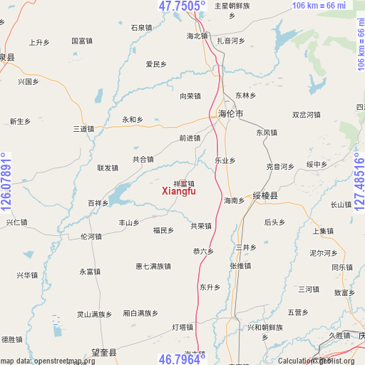
Xiangfu GPS coordinates[2]
47° 16' 32.16" North, 126° 46' 55.308" East
| Map corner | latitude | longitude |
|---|---|---|
| Upper-left | 47.7505°, | 126.07891° |
| Center: | 47.2756°, | 126.78203° |
| Lower-right: | 46.7964°, | 127.48516° |
| Map W x H: | 106.1×106.1 km | = 65.9×65.9mi |
| max Lat: | 53.31946° ⇑2.5% North |
| Xiangfu: | 47.2756° |
| min Lat: | ⇓97.5% South 18.22056° |
| min Long | Xiangfu | max Long |
| 75.07348° | 126.78203° | 134.28917° |
| W 96.3%⇐ | ⇒3.7% E |
Elevation
Elevation of Xiangfu is 202 m = 663 ft, and this is 282.8 m = 928 ft below average elevation for this country.
| Max E: |
5622 m = 18445 ft | 45.5% |
| Avg. | 484.8 m = 1591 ft | |
| Xiangfu | 202 m = 663 ft | |
Min E: |
-3 m = -10 ft | 54.5% |
See also: China elevation on elevation.city.
Geographical zone
Xiangfu is located in North temperate zone (between Tropic of Cancer and the Arctic Circle). Distance of this North polar circle is 2144.6 km =1332.6 mi to North.| Distance of | km | miles | from Xiangfu |
|---|---|---|---|
| North Pole | 4750.5 | 2951.8 | to North |
| Arctic Circle | 2144.6 | 1332.6 | to North |
| Tropic Cancer | 2650.6 | 1647 | to South |
| Equator | 5256.6 | 3266.3 | to South |


Nearby cities:
15 places around Xiangfu: (largest is in red/bold)
• Baixiang
25.5 km =15.8 mi,  256°
256°
• Fengshan
19.3 km =12 mi,  233°
233°
• Fumin
14.5 km =9 mi,  201°
201°
• Gonghe
13.8 km =8.6 mi,  302°
302°
• Gongliu
20.5 km =12.7 mi,  162°
162°
• Gongrong
13.4 km =8.3 mi, 156°
• Hailun
23.9 km =14.9 mi,  32°
32°
• Hainan
15.8 km =9.8 mi,  107°
107°
• Haixing
12.9 km =8 mi,  221°
221°
• Huiqi
25.5 km =15.8 mi, 199°
• Leye
12.6 km =7.8 mi,  81°
81°
• Lianfa
22.6 km =14 mi,  281°
281°
• Qianjin
13.7 km =8.5 mi,  9°
9°
• Suileng
23.8 km =14.8 mi,  97°
97°
• Yonghe
23.7 km =14.7 mi,  322°
322°
Sources, notices
• [Note1] Compared only with cities in China existing in our database
• [Src1] Map data: © OpenStreetMap contributors (CC-BY-SA)
• [Src2] Other city data from geonames.org with taken over terms of usage.
• [Src3] Geographical zone / Annual Mean Temperature by Robert A. Rohde @ Wikipedia
