Erenhot geodata
Erenhot (Inner Mongolia) is a seat of a third-order administrative division; located in China in Asia/Shanghai (GMT+8) time zone. With population of 16,427 people, there are 808 cities with bigger population in this country. Compared to other cities in China, 92.4% of cities are located further ↓South; 62.8% of cities are located further →East and 84.7% of cities have lower elevation than Erenhot. Note1


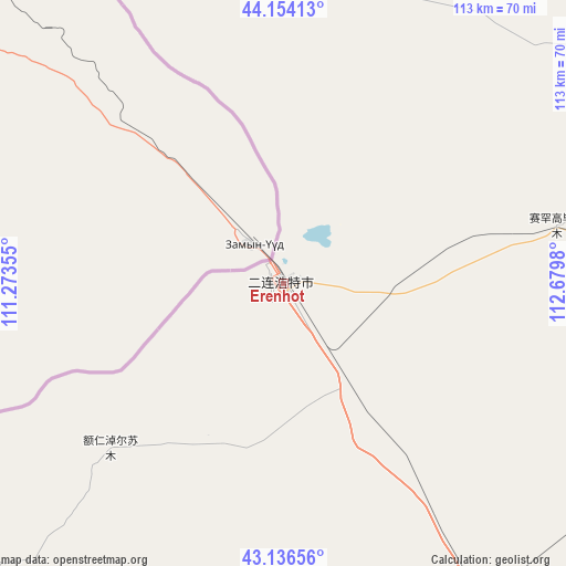
Erenhot GPS coordinates[2]
43° 38' 51" North, 111° 58' 36.012" East
| Map corner | latitude | longitude |
|---|---|---|
| Upper-left | 44.15413°, | 111.27355° |
| Center: | 43.6475°, | 111.97667° |
| Lower-right: | 43.13656°, | 112.6798° |
| Map W x H: | 113.1×113.1 km | = 70.3×70.3mi |
| max Lat: | 53.31946° ⇑7.6% North |
| Erenhot: | 43.6475° |
| min Lat: | ⇓92.4% South 18.22056° |
| min Long | Erenhot | max Long |
| 75.07348° | 111.97667° | 134.28917° |
| W 37.2%⇐ | ⇒62.8% E |
Elevation
Elevation of Erenhot is 965 m = 3166 ft, and this is 480.2 m = 1575 ft above average elevation for this country.
| Max E: |
5622 m = 18445 ft | 15.3% |
| Erenhot | 965 m 3166 ft | |
| Avg. | 484.8 m = 1591 ft | |
Min E: |
-3 m = -10 ft | 84.7% |
See also: China elevation on elevation.city.
Geographical zone
Erenhot is located in North temperate zone (between Tropic of Cancer and the Arctic Circle). Distance of this Northern Tropic circle is 2247.2 km =1396.3 mi to South.| Distance of | km | miles | from Erenhot |
|---|---|---|---|
| North Pole | 5153.9 | 3202.5 | to North |
| Arctic Circle | 2548 | 1583.3 | to North |
| Tropic Cancer | 2247.2 | 1396.3 | to South |
| Equator | 4853.1 | 3015.6 | to South |


Nearby cities:
15 places around Erenhot: (largest is in red/bold)
• Aguitu
228.9 km =142.2 mi,  155°
155°
• Bahaodi
209.7 km =130.3 mi, 157°
• Dalai
135.5 km =84.2 mi,  36°
36°
• Honggor
117.6 km =73.1 mi,  8°
8°
• Huashanzi
226 km =140.4 mi,  173°
173°
• Jigun Tala
220.5 km =137 mi, 158°
• Kulun
217.6 km =135.2 mi, 165°
• Mandalt
141.3 km =87.8 mi,  81°
81°
• Naran Bulag
202.9 km =126.1 mi,  57°
57°
• Qagan Obo
69.5 km =43.2 mi,  344°
344°
• Saihan Tal
115.2 km =71.6 mi,  151°
151°
• Sanjinquan
215.9 km =134.2 mi, 161°
• Tumu’ertai
222.2 km =138.1 mi, 154°
• Xin Bulag
217.9 km =135.4 mi,  136°
136°
• Yifaquan
229.5 km =142.6 mi, 168°
Sources, notices
• [Note1] Compared only with cities in China existing in our database
• [Src1] Map data: © OpenStreetMap contributors (CC-BY-SA)
• [Src2] Other city data from geonames.org with taken over terms of usage.
• [Src3] Geographical zone / Annual Mean Temperature by Robert A. Rohde @ Wikipedia
