Chaoyang geodata
Chaoyang (Liaoning) is a seat of a second-order administrative division; located in China in Asia/Shanghai (GMT+8) time zone. With population of 410,005 people, there are 150 cities with bigger population in this country. Compared to other cities in China, 90.3% of cities are located further ↓South; 84.8% of cities are located further ←West and 50.3% of cities have higher elevation than Chaoyang. Note1


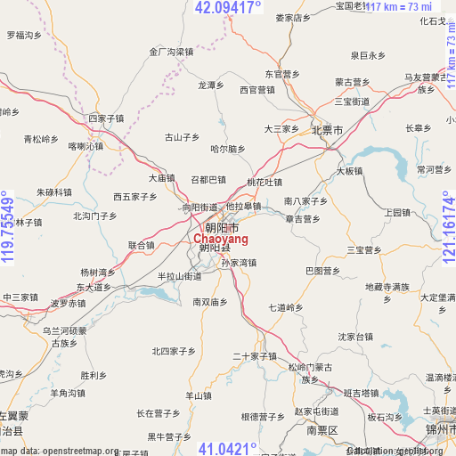
Chaoyang GPS coordinates[2]
41° 34' 13.008" North, 120° 27' 30.996" East
| Map corner | latitude | longitude |
|---|---|---|
| Upper-left | 42.09417°, | 119.75549° |
| Center: | 41.57028°, | 120.45861° |
| Lower-right: | 41.0421°, | 121.16174° |
| Map W x H: | 117×117 km | = 72.7×72.7mi |
| max Lat: | 53.31946° ⇑9.7% North |
| Chaoyang: | 41.57028° |
| min Lat: | ⇓90.3% South 18.22056° |
| min Long | Chaoyang | max Long |
| 75.07348° | 120.45861° | 134.28917° |
| W 84.8%⇐ | ⇒15.2% E |
Elevation
Elevation of Chaoyang is 162 m = 531 ft, and this is 322.8 m = 1059 ft below average elevation for this country.
| Max E: |
5622 m = 18445 ft | 50.3% |
| Avg. | 484.8 m = 1591 ft | |
| Chaoyang | 162 m = 531 ft | |
Min E: |
-3 m = -10 ft | 49.7% |
See also: Chaoyang elevation on elevation.city.
Geographical zone
Chaoyang is located in North temperate zone (between Tropic of Cancer and the Arctic Circle). Distance of this Northern Tropic circle is 2016.3 km =1252.9 mi to South.| Distance of | km | miles | from Chaoyang |
|---|---|---|---|
| North Pole | 5384.9 | 3346 | to North |
| Arctic Circle | 2779 | 1726.8 | to North |
| Tropic Cancer | 2016.3 | 1252.9 | to South |
| Equator | 4622.2 | 2872.1 | to South |


Nearby cities:
15 places around Chaoyang: (largest is in red/bold)
• Baimashi
73.3 km =45.5 mi,  187°
187°
• Beipiao
36.3 km =22.6 mi,  47°
47°
• Beisijia
66.5 km =41.3 mi,  15°
15°
• Gangtun
73.5 km =45.7 mi,  169°
169°
• Guzhuyingzi
72.1 km =44.8 mi, 192°
• Heichengzi
76.4 km =47.5 mi,  34°
34°
• Jinzhou
76.8 km =47.7 mi,  132°
132°
• Loujiadian
57 km =35.4 mi, 18°
• Nanpiao
57.8 km =35.9 mi,  155°
155°
• Nuanchitang
62.7 km =39 mi, 164°
• Shaguotun
52.5 km =32.6 mi, 158°
• Shanxi
70.7 km =43.9 mi, 174°
• Taijitun
66.7 km =41.4 mi,  148°
148°
• Wanghu
72 km =44.7 mi, 145°
• Yebaishou
70.8 km =44 mi,  254°
254°
Sources, notices
• [Note1] Compared only with cities in China existing in our database
• [Src1] Map data: © OpenStreetMap contributors (CC-BY-SA)
• [Src2] Other city data from geonames.org with taken over terms of usage.
• [Src3] Geographical zone / Annual Mean Temperature by Robert A. Rohde @ Wikipedia
