Yebaishou geodata
Yebaishou (Liaoning) is a populated place; located in China in Asia/Shanghai (GMT+8) time zone. With population of 65,536 people, there are 662 cities with bigger population in this country. Compared to other cities in China, 89.9% of cities are located further ↓South; 79.6% of cities are located further ←West and 70% of cities have lower elevation than Yebaishou. Note1


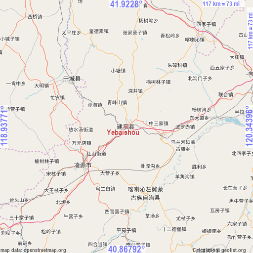
Yebaishou GPS coordinates[2]
41° 23' 51" North, 119° 38' 26.988" East
| Map corner | latitude | longitude |
|---|---|---|
| Upper-left | 41.9228°, | 118.93771° |
| Center: | 41.3975°, | 119.64083° |
| Lower-right: | 40.86792°, | 120.34396° |
| Map W x H: | 117.3×117.3 km | = 72.9×72.9mi |
| max Lat: | 53.31946° ⇑10.1% North |
| Yebaishou: | 41.3975° |
| min Lat: | ⇓89.9% South 18.22056° |
| min Long | Yebaishou | max Long |
| 75.07348° | 119.64083° | 134.28917° |
| W 79.6%⇐ | ⇒20.4% E |
Elevation
Elevation of Yebaishou is 412 m = 1352 ft, and this is 72.8 m = 239 ft below average elevation for this country.
| Max E: |
5622 m = 18445 ft | 30% |
| Avg. | 484.8 m = 1591 ft | |
| Yebaishou | 412 m = 1352 ft | |
Min E: |
-3 m = -10 ft | 70% |
See also: Yebaishou elevation on elevation.city.
Geographical zone
Yebaishou is located in North temperate zone (between Tropic of Cancer and the Arctic Circle). Distance of this Northern Tropic circle is 1997.1 km =1240.9 mi to South.| Distance of | km | miles | from Yebaishou |
|---|---|---|---|
| North Pole | 5404.1 | 3358 | to North |
| Arctic Circle | 2798.2 | 1738.7 | to North |
| Tropic Cancer | 1997.1 | 1240.9 | to South |
| Equator | 4603 | 2860.2 | to South |


Nearby cities:
15 places around Yebaishou: (largest is in red/bold)
• Baimashi
80 km =49.7 mi,  132°
132°
• Beiyingzi
83.3 km =51.8 mi,  211°
211°
• Chaoyang
70.8 km =44 mi,  74°
74°
• Gangtun
97.5 km =60.6 mi,  123°
123°
• Guzhuyingzi
73.2 km =45.5 mi, 134°
• Lingyuan
26.6 km =16.5 mi,  228°
228°
• Miaodong
21.5 km =13.4 mi, 232°
• Nanjie
64.8 km =40.3 mi, 229°
• Nuanchitang
94.9 km =59 mi, 115°
• Pingquan
91.3 km =56.7 mi,  241°
241°
• Pingzhuang
76.9 km =47.8 mi,  337°
337°
• Shaguotun
92.7 km =57.6 mi,  108°
108°
• Shanxi
91.2 km =56.7 mi, 124°
• Tianyi
31.8 km =19.8 mi,  306°
306°
• Xintaimen
90.3 km =56.1 mi, 133°
Sources, notices
• [Note1] Compared only with cities in China existing in our database
• [Src1] Map data: © OpenStreetMap contributors (CC-BY-SA)
• [Src2] Other city data from geonames.org with taken over terms of usage.
• [Src3] Geographical zone / Annual Mean Temperature by Robert A. Rohde @ Wikipedia
