Bei’an geodata
Bei’an (Heilongjiang) is a populated place; located in China in Asia/Shanghai (GMT+8) time zone. With population of 436,444 people, there are 144 cities with bigger population in this country. Compared to other cities in China, 98.7% of cities are located further ↓South; 96.1% of cities are located further ←West and 61.1% of cities have lower elevation than Bei’an. Note1


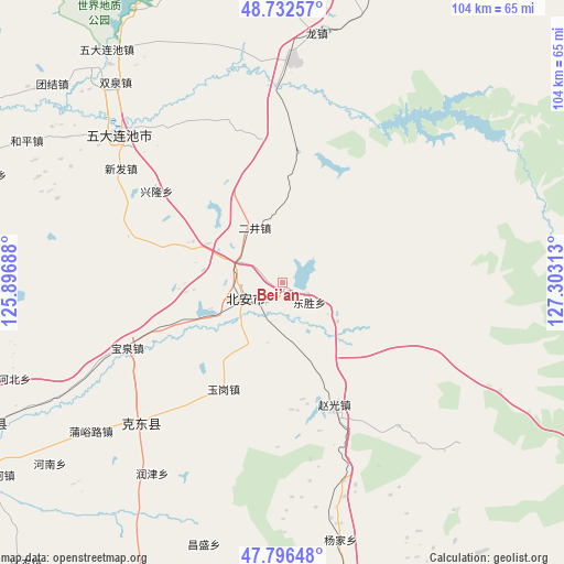
Bei’an GPS coordinates[2]
48° 16' 0.012" North, 126° 36' 0" East
| Map corner | latitude | longitude |
|---|---|---|
| Upper-left | 48.73257°, | 125.89688° |
| Center: | 48.26667°, | 126.6° |
| Lower-right: | 47.79648°, | 127.30313° |
| Map W x H: | 104.1×104.1 km | = 64.7×64.7mi |
| max Lat: | 53.31946° ⇑1.3% North |
| Bei’an: | 48.26667° |
| min Lat: | ⇓98.7% South 18.22056° |
| min Long | Bei’an | max Long |
| 75.07348° | 126.6° | 134.28917° |
| W 96.1%⇐ | ⇒3.9% E |
Elevation
Elevation of Bei’an is 273 m = 896 ft, and this is 211.8 m = 695 ft below average elevation for this country.
| Max E: |
5622 m = 18445 ft | 38.9% |
| Avg. | 484.8 m = 1591 ft | |
| Bei’an | 273 m = 896 ft | |
Min E: |
-3 m = -10 ft | 61.1% |
See also: Bei’an elevation on elevation.city.
Geographical zone
Bei’an is located in North temperate zone (between Tropic of Cancer and the Arctic Circle). Distance of this North polar circle is 2034.4 km =1264.1 mi to North.| Distance of | km | miles | from Bei’an |
|---|---|---|---|
| North Pole | 4640.3 | 2883.3 | to North |
| Arctic Circle | 2034.4 | 1264.1 | to North |
| Tropic Cancer | 2760.8 | 1715.5 | to South |
| Equator | 5366.8 | 3334.8 | to South |


Nearby cities:
15 places around Bei’an: (largest is in red/bold)
• Aiguo
57.5 km =35.7 mi,  194°
194°
• Baoquan
31.4 km =19.5 mi,  247°
247°
• Changsheng
50.7 km =31.5 mi,  196°
196°
• Chengjiao
8.4 km =5.2 mi,  234°
234°
• Dongsheng
5.8 km =3.6 mi,  130°
130°
• Erjing
15.5 km =9.6 mi,  297°
297°
• Haixing
61 km =37.9 mi,  157°
157°
• Henan
54.5 km =33.9 mi, 232°
• Jianguo
62.8 km =39 mi,  217°
217°
• Mingshan
32.9 km =20.4 mi, 234°
• Qianfeng
60.4 km =37.5 mi,  205°
205°
• Runjin
42.8 km =26.6 mi, 214°
• Shuangqing
37.1 km =23.1 mi, 204°
• Tongbei
56.5 km =35.1 mi,  167°
167°
• Yangjia
48.9 km =30.4 mi, 167°
Sources, notices
• [Note1] Compared only with cities in China existing in our database
• [Src1] Map data: © OpenStreetMap contributors (CC-BY-SA)
• [Src2] Other city data from geonames.org with taken over terms of usage.
• [Src3] Geographical zone / Annual Mean Temperature by Robert A. Rohde @ Wikipedia
