Erjing geodata
Erjing (Heilongjiang) is a seat of a fourth-order administrative division; located in China in Asia/Shanghai (GMT+8) time zone. In our database, there are 1268 cities with bigger population. Compared to other cities in China, 98.8% of cities are located further ↓South; 95.9% of cities are located further ←West and 63.3% of cities have lower elevation than Erjing. Note1


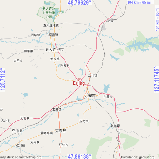
Erjing GPS coordinates[2]
48° 19' 51.528" North, 126° 24' 51.552" East
| Map corner | latitude | longitude |
|---|---|---|
| Upper-left | 48.79629°, | 125.7112° |
| Center: | 48.33098°, | 126.41432° |
| Lower-right: | 47.86138°, | 127.11745° |
| Map W x H: | 104×104 km | = 64.6×64.6mi |
| max Lat: | 53.31946° ⇑1.2% North |
| Erjing: | 48.33098° |
| min Lat: | ⇓98.8% South 18.22056° |
| min Long | Erjing | max Long |
| 75.07348° | 126.41432° | 134.28917° |
| W 95.9%⇐ | ⇒4.1% E |
Elevation
Elevation of Erjing is 302 m = 991 ft, and this is 182.8 m = 600 ft below average elevation for this country.
| Max E: |
5622 m = 18445 ft | 36.7% |
| Avg. | 484.8 m = 1591 ft | |
| Erjing | 302 m = 991 ft | |
Min E: |
-3 m = -10 ft | 63.3% |
See also: China elevation on elevation.city.
Geographical zone
Erjing is located in North temperate zone (between Tropic of Cancer and the Arctic Circle). Distance of this North polar circle is 2027.3 km =1259.7 mi to North.| Distance of | km | miles | from Erjing |
|---|---|---|---|
| North Pole | 4633.2 | 2878.9 | to North |
| Arctic Circle | 2027.3 | 1259.7 | to North |
| Tropic Cancer | 2768 | 1720 | to South |
| Equator | 5373.9 | 3339.2 | to South |


Nearby cities:
15 places around Erjing: (largest is in red/bold)
• Aiguo
62.8 km =39 mi,  180°
180°
• Baoquan
24.5 km =15.2 mi,  218°
218°
• Bei’an
15.5 km =9.6 mi,  117°
117°
• Changsheng
55.8 km =34.7 mi, 180°
• Chengjiao
13.9 km =8.6 mi,  150°
150°
• Dongsheng
21.2 km =13.2 mi, 120°
• Henan
50.1 km =31.1 mi, 215°
• Jianguo
61.9 km =38.5 mi,  203°
203°
• Mingshan
29.2 km =18.1 mi,  206°
206°
• Qianfeng
62.8 km =39 mi,  191°
191°
• Runjin
43.8 km =27.2 mi, 193°
• Shuanghe
57.8 km =35.9 mi, 222°
• Shuangqing
41.1 km =25.5 mi, 181°
• Tongbei
67.5 km =41.9 mi,  157°
157°
• Yangjia
60.1 km =37.3 mi, 155°
Sources, notices
• [Note1] Compared only with cities in China existing in our database
• [Src1] Map data: © OpenStreetMap contributors (CC-BY-SA)
• [Src2] Other city data from geonames.org with taken over terms of usage.
• [Src3] Geographical zone / Annual Mean Temperature by Robert A. Rohde @ Wikipedia
