Hou’an geodata
Hou’an (Liaoning) is a seat of a fourth-order administrative division; located in China in Asia/Shanghai (GMT+8) time zone. In our database, there are 1268 cities with bigger population. Compared to other cities in China, 90.5% of cities are located further ↓South; 94.1% of cities are located further ←West and 54.6% of cities have lower elevation than Hou’an. Note1


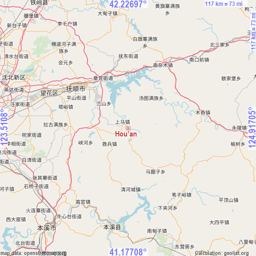
Hou’an GPS coordinates[2]
41° 42' 15.012" North, 124° 12' 50.112" East
| Map corner | latitude | longitude |
|---|---|---|
| Upper-left | 42.22697°, | 123.5108° |
| Center: | 41.70417°, | 124.21392° |
| Lower-right: | 41.17708°, | 124.91705° |
| Map W x H: | 116.7×116.7 km | = 72.5×72.5mi |
| max Lat: | 53.31946° ⇑9.5% North |
| Hou’an: | 41.70417° |
| min Lat: | ⇓90.5% South 18.22056° |
| min Long | Hou’an | max Long |
| 75.07348° | 124.21392° | 134.28917° |
| W 94.1%⇐ | ⇒5.9% E |
Elevation
Elevation of Hou’an is 203 m = 666 ft, and this is 281.8 m = 925 ft below average elevation for this country.
| Max E: |
5622 m = 18445 ft | 45.4% |
| Avg. | 484.8 m = 1591 ft | |
| Hou’an | 203 m = 666 ft | |
Min E: |
-3 m = -10 ft | 54.6% |
See also: China elevation on elevation.city.
Geographical zone
Hou’an is located in North temperate zone (between Tropic of Cancer and the Arctic Circle). Distance of this Northern Tropic circle is 2031.2 km =1262.1 mi to South.| Distance of | km | miles | from Hou’an |
|---|---|---|---|
| North Pole | 5370 | 3336.8 | to North |
| Arctic Circle | 2764.1 | 1717.5 | to North |
| Tropic Cancer | 2031.2 | 1262.1 | to South |
| Equator | 4637.1 | 2881.4 | to South |


Nearby cities:
15 places around Hou’an: (largest is in red/bold)
• Dongzhou
23 km =14.3 mi,  320°
320°
• Fushun
30.2 km =18.8 mi,  312°
312°
• Hada
30.4 km =18.9 mi,  348°
348°
• Jiubing
11 km =6.8 mi,  231°
231°
• Lanshan
14.5 km =9 mi, 317°
• Majuanzi
23.7 km =14.7 mi,  146°
146°
• Nianpan
19.6 km =12.2 mi, 311°
• Qiandian
27.5 km =17.1 mi, 320°
• Qinghecheng
27.8 km =17.3 mi,  178°
178°
• Shangjiahe
27.7 km =17.2 mi,  54°
54°
• Shangma
10.1 km =6.3 mi,  328°
328°
• Tangtu
17.1 km =10.6 mi,  36°
36°
• Xiayingzi
28.2 km =17.5 mi,  85°
85°
• Zhangdang
25.4 km =15.8 mi, 332°
• Zhangdian
19 km =11.8 mi, 311°
Sources, notices
• [Note1] Compared only with cities in China existing in our database
• [Src1] Map data: © OpenStreetMap contributors (CC-BY-SA)
• [Src2] Other city data from geonames.org with taken over terms of usage.
• [Src3] Geographical zone / Annual Mean Temperature by Robert A. Rohde @ Wikipedia
