Jiubing geodata
Jiubing (Liaoning) is a seat of a fourth-order administrative division; located in China in Asia/Shanghai (GMT+8) time zone. In our database, there are 1268 cities with bigger population. Compared to other cities in China, 90.4% of cities are located further ↓South; 93.9% of cities are located further ←West and 56.2% of cities have lower elevation than Jiubing. Note1


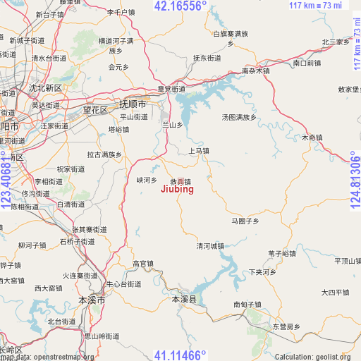
Jiubing GPS coordinates[2]
41° 38' 32.1" North, 124° 6' 35.748" East
| Map corner | latitude | longitude |
|---|---|---|
| Upper-left | 42.16556°, | 123.40681° |
| Center: | 41.64225°, | 124.10993° |
| Lower-right: | 41.11466°, | 124.81306° |
| Map W x H: | 116.8×116.8 km | = 72.6×72.6mi |
| max Lat: | 53.31946° ⇑9.6% North |
| Jiubing: | 41.64225° |
| min Lat: | ⇓90.4% South 18.22056° |
| min Long | Jiubing | max Long |
| 75.07348° | 124.10993° | 134.28917° |
| W 93.9%⇐ | ⇒6.1% E |
Elevation
Elevation of Jiubing is 218 m = 715 ft, and this is 266.8 m = 875 ft below average elevation for this country.
| Max E: |
5622 m = 18445 ft | 43.8% |
| Avg. | 484.8 m = 1591 ft | |
| Jiubing | 218 m = 715 ft | |
Min E: |
-3 m = -10 ft | 56.2% |
See also: China elevation on elevation.city.
Geographical zone
Jiubing is located in North temperate zone (between Tropic of Cancer and the Arctic Circle). Distance of this Northern Tropic circle is 2024.3 km =1257.8 mi to South.| Distance of | km | miles | from Jiubing |
|---|---|---|---|
| North Pole | 5376.9 | 3341 | to North |
| Arctic Circle | 2771 | 1721.8 | to North |
| Tropic Cancer | 2024.3 | 1257.8 | to South |
| Equator | 4630.2 | 2877.1 | to South |


Nearby cities:
15 places around Jiubing: (largest is in red/bold)
• Dongzhou
25.4 km =15.8 mi,  346°
346°
• Fushun
30.5 km =19 mi,  333°
333°
• Guanyinge
36.6 km =22.7 mi,  179°
179°
• Hada
36.7 km =22.8 mi,  4°
4°
• Hou’an
11 km =6.8 mi,  51°
51°
• Lanshan
17.5 km =10.9 mi,  355°
355°
• Majuanzi
25.2 km =15.7 mi,  121°
121°
• Nianpan
20.8 km =12.9 mi,  343°
343°
• Qiandian
29.4 km =18.3 mi, 342°
• Qinghecheng
23 km =14.3 mi,  155°
155°
• Shangma
15.8 km =9.8 mi,  12°
12°
• Tangtu
27.9 km =17.3 mi,  42°
42°
• Xiayingzi
37.8 km =23.5 mi,  76°
76°
• Zhangdang
29.6 km =18.4 mi, 354°
• Zhangdian
20.3 km =12.6 mi, 343°
Sources, notices
• [Note1] Compared only with cities in China existing in our database
• [Src1] Map data: © OpenStreetMap contributors (CC-BY-SA)
• [Src2] Other city data from geonames.org with taken over terms of usage.
• [Src3] Geographical zone / Annual Mean Temperature by Robert A. Rohde @ Wikipedia
