Xiayang geodata
Xiayang (Guangdong) is a seat of a fourth-order administrative division; located in China in Asia/Urumqi (GMT+6) time zone. In our database, there are 1268 cities with bigger population. Compared to other cities in China, 98.6% of cities are located further ↑North; 69.1% of cities are located further →East and 83.4% of cities have higher elevation than Xiayang. Note1


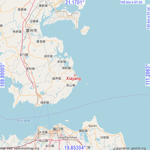
Xiayang GPS coordinates[2]
20° 30' 46.764" North, 110° 30' 11.412" East
| Map corner | latitude | longitude |
|---|---|---|
| Upper-left | 21.1701°, | 109.80005° |
| Center: | 20.51299°, | 110.50317° |
| Lower-right: | 19.85304°, | 111.2063° |
| Map W x H: | 146.4×146.4 km | = 91×91mi |
| max Lat: | 53.31946° ⇑98.6% North |
| Xiayang: | 20.51299° |
| min Lat: | ⇓1.4% South 18.22056° |
| min Long | Xiayang | max Long |
| 75.07348° | 110.50317° | 134.28917° |
| W 30.9%⇐ | ⇒69.1% E |
Elevation
Elevation of Xiayang is 19 m = 62 ft, and this is 465.8 m = 1528 ft below average elevation for this country.
| Max E: |
5622 m = 18445 ft | 83.4% |
| Avg. | 484.8 m = 1591 ft | |
| Xiayang | 19 m = 62 ft | |
Min E: |
-3 m = -10 ft | 16.6% |
See also: China elevation on elevation.city.
Geographical zone
Xiayang is located in North Torrid zone (between Equator and Tropic of Cancer). Distance of this Northern Tropic circle is 325.1 km =202 mi to North.| Distance of | km | miles | from Xiayang |
|---|---|---|---|
| North Pole | 7726.2 | 4800.8 | to North |
| Arctic Circle | 5120.3 | 3181.6 | to North |
| Tropic Cancer | 325.1 | 202 | to North |
| Equator | 2280.8 | 1417.2 | to South |


Nearby cities:
15 places around Xiayang: (largest is in red/bold)
• Chengbei
39.8 km =24.7 mi,  238°
238°
• Dongli
34.4 km =21.4 mi,  334°
334°
• Hai’an
38.6 km =24 mi,  227°
227°
• He’an
19 km =11.8 mi,  313°
313°
• Jinhe
11.6 km =7.2 mi,  303°
303°
• Leigao
46.1 km =28.6 mi,  315°
315°
• Longtang
27.1 km =16.8 mi,  218°
218°
• Nanshan
41.7 km =25.9 mi, 237°
• Qianshan
10.5 km =6.5 mi,  204°
204°
• Qujie
18.7 km =11.6 mi,  260°
260°
• Tiaofeng
32.5 km =20.2 mi, 306°
• Xiaqiao
39.3 km =24.4 mi, 259°
• Xinliao
12.7 km =7.9 mi,  340°
340°
• Xucheng
40.5 km =25.2 mi, 239°
• Yingli
42.7 km =26.5 mi,  277°
277°
Sources, notices
• [Note1] Compared only with cities in China existing in our database
• [Src1] Map data: © OpenStreetMap contributors (CC-BY-SA)
• [Src2] Other city data from geonames.org with taken over terms of usage.
• [Src3] Geographical zone / Annual Mean Temperature by Robert A. Rohde @ Wikipedia
