Qianshan geodata
Qianshan (Guangdong) is a seat of a fourth-order administrative division; located in China in Asia/Urumqi (GMT+6) time zone. In our database, there are 1268 cities with bigger population. Compared to other cities in China, 98.6% of cities are located further ↑North; 69.2% of cities are located further →East and 75.7% of cities have higher elevation than Qianshan. Note1


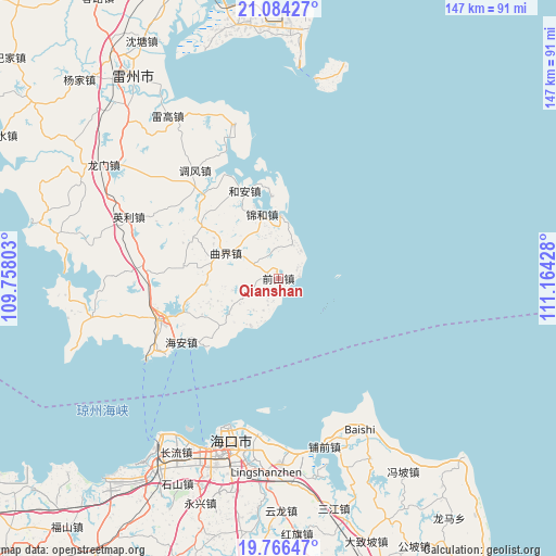
Qianshan GPS coordinates[2]
20° 25' 36.408" North, 110° 27' 40.14" East
| Map corner | latitude | longitude |
|---|---|---|
| Upper-left | 21.08427°, | 109.75803° |
| Center: | 20.42678°, | 110.46115° |
| Lower-right: | 19.76647°, | 111.16428° |
| Map W x H: | 146.5×146.5 km | = 91×91mi |
| max Lat: | 53.31946° ⇑98.6% North |
| Qianshan: | 20.42678° |
| min Lat: | ⇓1.4% South 18.22056° |
| min Long | Qianshan | max Long |
| 75.07348° | 110.46115° | 134.28917° |
| W 30.8%⇐ | ⇒69.2% E |
Elevation
Elevation of Qianshan is 35 m = 115 ft, and this is 449.8 m = 1476 ft below average elevation for this country.
| Max E: |
5622 m = 18445 ft | 75.7% |
| Avg. | 484.8 m = 1591 ft | |
| Qianshan | 35 m = 115 ft | |
Min E: |
-3 m = -10 ft | 24.3% |
See also: China elevation on elevation.city.
Geographical zone
Qianshan is located in North Torrid zone (between Equator and Tropic of Cancer). Distance of this Northern Tropic circle is 334.7 km =208 mi to North.| Distance of | km | miles | from Qianshan |
|---|---|---|---|
| North Pole | 7735.8 | 4806.8 | to North |
| Arctic Circle | 5129.9 | 3187.6 | to North |
| Tropic Cancer | 334.7 | 208 | to North |
| Equator | 2271.2 | 1411.3 | to South |


Nearby cities:
15 places around Qianshan: (largest is in red/bold)
• Chengbei
31.6 km =19.6 mi,  248°
248°
• Dongli
41.9 km =26 mi,  345°
345°
• Dongying
41.9 km =26 mi,  186°
186°
• Hai’an
29.2 km =18.1 mi,  236°
236°
• He’an
24.5 km =15.2 mi,  337°
337°
• Jinhe
16.8 km =10.4 mi, 341°
• Longtang
17.1 km =10.6 mi,  226°
226°
• Nanshan
33.4 km =20.8 mi, 247°
• Qujie
15.6 km =9.7 mi,  294°
294°
• Tiaofeng
36.2 km =22.5 mi,  322°
322°
• Xiaqiao
34.3 km =21.3 mi,  274°
274°
• Xiayang
10.5 km =6.5 mi,  24°
24°
• Xinliao
21.5 km =13.4 mi,  0°
0°
• Xucheng
32.5 km =20.2 mi, 250°
• Yingli
41 km =25.5 mi, 291°
Sources, notices
• [Note1] Compared only with cities in China existing in our database
• [Src1] Map data: © OpenStreetMap contributors (CC-BY-SA)
• [Src2] Other city data from geonames.org with taken over terms of usage.
• [Src3] Geographical zone / Annual Mean Temperature by Robert A. Rohde @ Wikipedia
