Suining geodata
Suining (Sichuan) is a seat of a third-order administrative division; located in China in Asia/Shanghai (GMT+8) time zone. With population of 124,924 people, there are 352 cities with bigger population in this country. Compared to other cities in China, 50.4% of cities are located further ↓South; 88.1% of cities are located further →East and 62.6% of cities have lower elevation than Suining. Note1


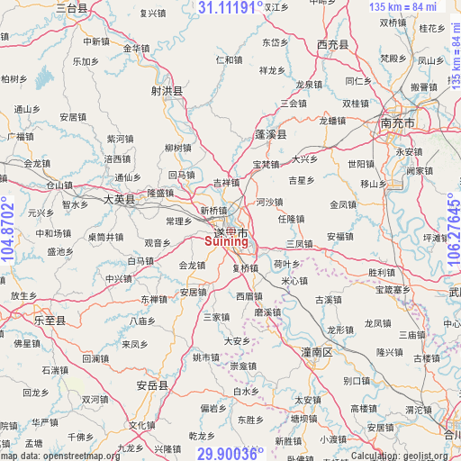
Suining GPS coordinates[2]
30° 30' 28.872" North, 105° 34' 23.952" East
| Map corner | latitude | longitude |
|---|---|---|
| Upper-left | 31.11191°, | 104.8702° |
| Center: | 30.50802°, | 105.57332° |
| Lower-right: | 29.90036°, | 106.27645° |
| Map W x H: | 134.7×134.7 km | = 83.7×83.7mi |
| max Lat: | 53.31946° ⇑49.6% North |
| Suining: | 30.50802° |
| min Lat: | ⇓50.4% South 18.22056° |
| min Long | Suining | max Long |
| 75.07348° | 105.57332° | 134.28917° |
| W 11.9%⇐ | ⇒88.1% E |
Elevation
Elevation of Suining is 291 m = 955 ft, and this is 193.8 m = 636 ft below average elevation for this country.
| Max E: |
5622 m = 18445 ft | 37.4% |
| Avg. | 484.8 m = 1591 ft | |
| Suining | 291 m = 955 ft | |
Min E: |
-3 m = -10 ft | 62.6% |
See also: Suining elevation on elevation.city.
Geographical zone
Suining is located in North temperate zone (between Tropic of Cancer and the Arctic Circle). Distance of this Northern Tropic circle is 786.3 km =488.6 mi to South.| Distance of | km | miles | from Suining |
|---|---|---|---|
| North Pole | 6614.9 | 4110.3 | to North |
| Arctic Circle | 4009 | 2491.1 | to North |
| Tropic Cancer | 786.3 | 488.6 | to South |
| Equator | 3392.2 | 2107.8 | to South |


Nearby cities:
15 places around Suining: (largest is in red/bold)
• Anju
20.9 km =13 mi,  212°
212°
• Baolong
37.4 km =23.2 mi,  117°
117°
• Chicheng
33 km =20.5 mi,  23°
23°
• Chongkan
39.4 km =24.5 mi,  174°
174°
• Erlang
43.3 km =26.9 mi,  111°
111°
• Guxi
34.8 km =21.6 mi, 124°
• Huayan
28.7 km =17.8 mi, 166°
• Longxing
43 km =26.7 mi,  131°
131°
• Mixin
23.5 km =14.6 mi, 127°
• Penglai
31.9 km =19.8 mi,  284°
284°
• Qunli
34.2 km =21.3 mi, 132°
• Shuangjiang
36.3 km =22.6 mi,  152°
152°
• Taihe
44.2 km =27.5 mi,  335°
335°
• Yuxi
28.3 km =17.6 mi,  136°
136°
• Zitong
44.2 km =27.5 mi, 146°
Sources, notices
• [Note1] Compared only with cities in China existing in our database
• [Src1] Map data: © OpenStreetMap contributors (CC-BY-SA)
• [Src2] Other city data from geonames.org with taken over terms of usage.
• [Src3] Geographical zone / Annual Mean Temperature by Robert A. Rohde @ Wikipedia
