Gaopo geodata
Gaopo (Sichuan) is a seat of a fourth-order administrative division; located in China in Asia/Shanghai (GMT+8) time zone. In our database, there are 1268 cities with bigger population. Compared to other cities in China, 61.7% of cities are located further ↓South; 85.7% of cities are located further →East and 85.8% of cities have lower elevation than Gaopo. Note1


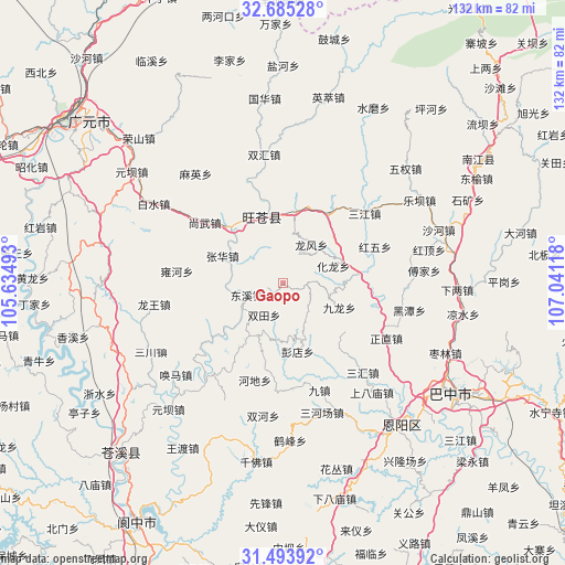
Gaopo GPS coordinates[2]
32° 5' 29.544" North, 106° 20' 16.98" East
| Map corner | latitude | longitude |
|---|---|---|
| Upper-left | 32.68528°, | 105.63493° |
| Center: | 32.09154°, | 106.33805° |
| Lower-right: | 31.49392°, | 107.04118° |
| Map W x H: | 132.5×132.5 km | = 82.3×82.3mi |
| max Lat: | 53.31946° ⇑38.3% North |
| Gaopo: | 32.09154° |
| min Lat: | ⇓61.7% South 18.22056° |
| min Long | Gaopo | max Long |
| 75.07348° | 106.33805° | 134.28917° |
| W 14.3%⇐ | ⇒85.7% E |
Elevation
Elevation of Gaopo is 1029 m = 3376 ft, and this is 544.2 m = 1785 ft above average elevation for this country.
| Max E: |
5622 m = 18445 ft | 14.2% |
| Gaopo | 1029 m 3376 ft | |
| Avg. | 484.8 m = 1591 ft | |
Min E: |
-3 m = -10 ft | 85.8% |
See also: China elevation on elevation.city.
Geographical zone
Gaopo is located in North temperate zone (between Tropic of Cancer and the Arctic Circle). Distance of this Northern Tropic circle is 962.3 km =597.9 mi to South.| Distance of | km | miles | from Gaopo |
|---|---|---|---|
| North Pole | 6438.8 | 4000.9 | to North |
| Arctic Circle | 3832.9 | 2381.7 | to North |
| Tropic Cancer | 962.3 | 597.9 | to South |
| Equator | 3568.2 | 2217.2 | to South |


Nearby cities:
15 places around Gaopo: (largest is in red/bold)
• Donghe
16.2 km =10.1 mi,  347°
347°
• Dongxi
8.9 km =5.5 mi,  251°
251°
• Heitan
30.3 km =18.8 mi,  102°
102°
• Heping
21.2 km =13.2 mi, 103°
• Hualong
12.4 km =7.7 mi,  70°
70°
• Huangmao
5.6 km =3.5 mi,  89°
89°
• Huangyang
16.6 km =10.3 mi,  9°
9°
• Jiachuan
17.5 km =10.9 mi,  318°
318°
• Longfeng
10.8 km =6.7 mi,  35°
35°
• Mumen
17.8 km =11.1 mi,  83°
83°
• Puji
19.7 km =12.2 mi,  33°
33°
• Sanjiang
25.1 km =15.6 mi,  49°
49°
• Shangwu
23.1 km =14.4 mi,  307°
307°
• Shima
12.2 km =7.6 mi,  135°
135°
• Zhanghua
15.7 km =9.8 mi,  293°
293°
Sources, notices
• [Note1] Compared only with cities in China existing in our database
• [Src1] Map data: © OpenStreetMap contributors (CC-BY-SA)
• [Src2] Other city data from geonames.org with taken over terms of usage.
• [Src3] Geographical zone / Annual Mean Temperature by Robert A. Rohde @ Wikipedia
