Yongchang geodata
Yongchang (Sichuan) is a seat of a third-order administrative division; located in China in Asia/Shanghai (GMT+8) time zone. In our database, there are 1268 cities with bigger population. Compared to other cities in China, 59.3% of cities are located further ↓South; 89.7% of cities are located further →East and 84.4% of cities have lower elevation than Yongchang. Note1


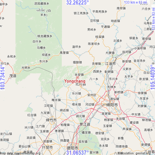
Yongchang GPS coordinates[2]
31° 39' 56.664" North, 104° 26' 14.136" East
| Map corner | latitude | longitude |
|---|---|---|
| Upper-left | 32.26225°, | 103.73414° |
| Center: | 31.66574°, | 104.43726° |
| Lower-right: | 31.06537°, | 105.14039° |
| Map W x H: | 133.1×133.1 km | = 82.7×82.7mi |
| max Lat: | 53.31946° ⇑40.7% North |
| Yongchang: | 31.66574° |
| min Lat: | ⇓59.3% South 18.22056° |
| min Long | Yongchang | max Long |
| 75.07348° | 104.43726° | 134.28917° |
| W 10.3%⇐ | ⇒89.7% E |
Elevation
Elevation of Yongchang is 942 m = 3091 ft, and this is 457.2 m = 1500 ft above average elevation for this country.
| Max E: |
5622 m = 18445 ft | 15.6% |
| Yongchang | 942 m 3091 ft | |
| Avg. | 484.8 m = 1591 ft | |
Min E: |
-3 m = -10 ft | 84.4% |
See also: China elevation on elevation.city.
Geographical zone
Yongchang is located in North temperate zone (between Tropic of Cancer and the Arctic Circle). Distance of this Northern Tropic circle is 915 km =568.6 mi to South.| Distance of | km | miles | from Yongchang |
|---|---|---|---|
| North Pole | 6486.2 | 4030.3 | to North |
| Arctic Circle | 3880.3 | 2411.1 | to North |
| Tropic Cancer | 915 | 568.6 | to South |
| Equator | 3520.9 | 2187.8 | to South |


Nearby cities:
15 places around Yongchang: (largest is in red/bold)
• Deyang
59.8 km =37.2 mi,  185°
185°
• Fangting
65.1 km =40.5 mi,  203°
203°
• Fengyi
55.2 km =34.3 mi,  272°
272°
• Huagai
17.4 km =10.8 mi,  139°
139°
• Jiangyou
28.7 km =17.8 mi,  66°
66°
• Jiannan
42.5 km =26.4 mi,  212°
212°
• Kaijiang
73.2 km =45.5 mi,  162°
162°
• Long’an
83.1 km =51.6 mi,  5°
5°
• Luocheng
77.7 km =48.3 mi, 191°
• Luojiang
40.6 km =25.2 mi,  170°
170°
• Mianyang
31.9 km =19.8 mi,  133°
133°
• Tongchuan
88.6 km =55.1 mi, 135°
• Weizhou
83 km =51.6 mi,  256°
256°
• Wenchang
68 km =42.3 mi,  92°
92°
• Zhongba
31.2 km =19.4 mi, 66°
Sources, notices
• [Note1] Compared only with cities in China existing in our database
• [Src1] Map data: © OpenStreetMap contributors (CC-BY-SA)
• [Src2] Other city data from geonames.org with taken over terms of usage.
• [Src3] Geographical zone / Annual Mean Temperature by Robert A. Rohde @ Wikipedia
