Tongchuan geodata
Tongchuan (Sichuan) is a seat of a third-order administrative division; located in China in Asia/Shanghai (GMT+8) time zone. With population of 58,346 people, there are 755 cities with bigger population in this country. Compared to other cities in China, 55.5% of cities are located further ↓South; 88.9% of cities are located further →East and 68.5% of cities have lower elevation than Tongchuan. Note1


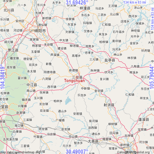
Tongchuan GPS coordinates[2]
31° 5' 38.652" North, 105° 5' 14.316" East
| Map corner | latitude | longitude |
|---|---|---|
| Upper-left | 31.69426°, | 104.38419° |
| Center: | 31.09407°, | 105.08731° |
| Lower-right: | 30.49007°, | 105.79044° |
| Map W x H: | 133.9×133.9 km | = 83.2×83.2mi |
| max Lat: | 53.31946° ⇑44.5% North |
| Tongchuan: | 31.09407° |
| min Lat: | ⇓55.5% South 18.22056° |
| min Long | Tongchuan | max Long |
| 75.07348° | 105.08731° | 134.28917° |
| W 11.1%⇐ | ⇒88.9% E |
Elevation
Elevation of Tongchuan is 386 m = 1266 ft, and this is 98.8 m = 324 ft below average elevation for this country.
| Max E: |
5622 m = 18445 ft | 31.5% |
| Avg. | 484.8 m = 1591 ft | |
| Tongchuan | 386 m = 1266 ft | |
Min E: |
-3 m = -10 ft | 68.5% |
See also: Tongchuan elevation on elevation.city.
Geographical zone
Tongchuan is located in North temperate zone (between Tropic of Cancer and the Arctic Circle). Distance of this Northern Tropic circle is 851.4 km =529 mi to South.| Distance of | km | miles | from Tongchuan |
|---|---|---|---|
| North Pole | 6549.7 | 4069.8 | to North |
| Arctic Circle | 3943.8 | 2450.6 | to North |
| Tropic Cancer | 851.4 | 529 | to South |
| Equator | 3457.3 | 2148.3 | to South |


Nearby cities:
15 places around Tongchuan: (largest is in red/bold)
• Chicheng
69.1 km =42.9 mi,  120°
120°
• Deyang
67.3 km =41.8 mi,  273°
273°
• Huagai
71.3 km =44.3 mi,  314°
314°
• Jiangyou
82.6 km =51.3 mi,  334°
334°
• Jincheng
76.5 km =47.5 mi,  98°
98°
• Kaijiang
39.8 km =24.7 mi,  261°
261°
• Luocheng
77.9 km =48.4 mi, 260°
• Luojiang
60.2 km =37.4 mi,  292°
292°
• Mianyang
56.7 km =35.2 mi,  317°
317°
• Penglai
59 km =36.7 mi,  164°
164°
• Suining
80 km =49.7 mi,  144°
144°
• Taihe
37.6 km =23.4 mi,  131°
131°
• Wenchang
60.6 km =37.7 mi,  6°
6°
• Yunxi
32 km =19.9 mi,  62°
62°
• Zhaozhen
67.5 km =41.9 mi,  246°
246°
Sources, notices
• [Note1] Compared only with cities in China existing in our database
• [Src1] Map data: © OpenStreetMap contributors (CC-BY-SA)
• [Src2] Other city data from geonames.org with taken over terms of usage.
• [Src3] Geographical zone / Annual Mean Temperature by Robert A. Rohde @ Wikipedia
