Luojiang geodata
Luojiang (Sichuan) is a seat of a third-order administrative division; located in China in Asia/Shanghai (GMT+8) time zone. In our database, there are 1268 cities with bigger population. Compared to other cities in China, 57.1% of cities are located further ↓South; 89.7% of cities are located further →East and 74.4% of cities have lower elevation than Luojiang. Note1


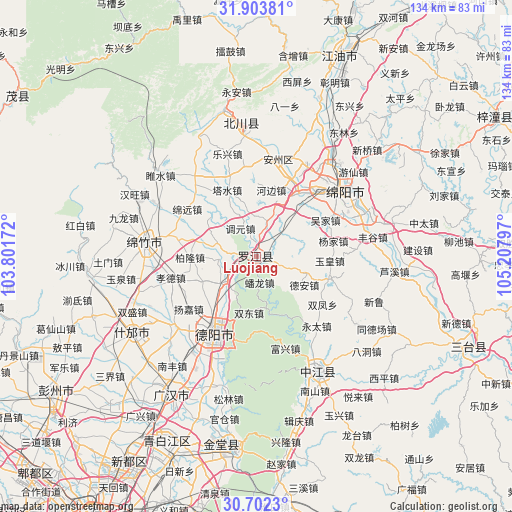
Luojiang GPS coordinates[2]
31° 18' 17.892" North, 104° 30' 17.424" East
| Map corner | latitude | longitude |
|---|---|---|
| Upper-left | 31.90381°, | 103.80172° |
| Center: | 31.30497°, | 104.50484° |
| Lower-right: | 30.7023°, | 105.20797° |
| Map W x H: | 133.6×133.6 km | = 83×83mi |
| max Lat: | 53.31946° ⇑42.9% North |
| Luojiang: | 31.30497° |
| min Lat: | ⇓57.1% South 18.22056° |
| min Long | Luojiang | max Long |
| 75.07348° | 104.50484° | 134.28917° |
| W 10.3%⇐ | ⇒89.7% E |
Elevation
Elevation of Luojiang is 509 m = 1670 ft, and this is 24.2 m = 79 ft above average elevation for this country.
| Max E: |
5622 m = 18445 ft | 25.6% |
| Luojiang | 509 m 1670 ft | |
| Avg. | 484.8 m = 1591 ft | |
Min E: |
-3 m = -10 ft | 74.4% |
See also: China elevation on elevation.city.
Geographical zone
Luojiang is located in North temperate zone (between Tropic of Cancer and the Arctic Circle). Distance of this Northern Tropic circle is 874.9 km =543.6 mi to South.| Distance of | km | miles | from Luojiang |
|---|---|---|---|
| North Pole | 6526.3 | 4055.3 | to North |
| Arctic Circle | 3920.4 | 2436 | to North |
| Tropic Cancer | 874.9 | 543.6 | to South |
| Equator | 3480.8 | 2162.9 | to South |


Nearby cities:
15 places around Luojiang: (largest is in red/bold)
• Deyang
22.7 km =14.1 mi,  211°
211°
• Fangting
37.7 km =23.4 mi,  238°
238°
• Huagai
27.3 km =17 mi,  10°
10°
• Jiangyou
55.1 km =34.2 mi,  21°
21°
• Jiannan
29.7 km =18.5 mi,  278°
278°
• Kaijiang
33.6 km =20.9 mi,  151°
151°
• Luocheng
41.9 km =26 mi, 210°
• Mianyang
24.7 km =15.3 mi,  42°
42°
• Tianpeng
64.4 km =40 mi, 236°
• Tongchuan
60.2 km =37.4 mi,  112°
112°
• Wenchang
71.8 km =44.6 mi,  59°
59°
• Xindu
63 km =39.1 mi, 211°
• Yongchang
40.6 km =25.2 mi,  350°
350°
• Zhaozhen
50.3 km =31.3 mi,  187°
187°
• Zhongba
57.1 km =35.5 mi, 22°
Sources, notices
• [Note1] Compared only with cities in China existing in our database
• [Src1] Map data: © OpenStreetMap contributors (CC-BY-SA)
• [Src2] Other city data from geonames.org with taken over terms of usage.
• [Src3] Geographical zone / Annual Mean Temperature by Robert A. Rohde @ Wikipedia
