Xinglin geodata
Xinglin (Shaanxi) is a seat of a fourth-order administrative division; located in China in Asia/Shanghai (GMT+8) time zone. In our database, there are 1268 cities with bigger population. Compared to other cities in China, 72.7% of cities are located further ↓South; 72.5% of cities are located further →East and 69.4% of cities have lower elevation than Xinglin. Note1


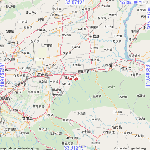
Xinglin GPS coordinates[2]
34° 29' 37.356" North, 109° 45' 38.52" East
| Map corner | latitude | longitude |
|---|---|---|
| Upper-left | 35.0712°, | 109.05758° |
| Center: | 34.49371°, | 109.7607° |
| Lower-right: | 33.91219°, | 110.46383° |
| Map W x H: | 128.9×128.9 km | = 80.1×80.1mi |
| max Lat: | 53.31946° ⇑27.3% North |
| Xinglin: | 34.49371° |
| min Lat: | ⇓72.7% South 18.22056° |
| min Long | Xinglin | max Long |
| 75.07348° | 109.7607° | 134.28917° |
| W 27.5%⇐ | ⇒72.5% E |
Elevation
Elevation of Xinglin is 400 m = 1312 ft, and this is 84.8 m = 278 ft below average elevation for this country.
| Max E: |
5622 m = 18445 ft | 30.6% |
| Avg. | 484.8 m = 1591 ft | |
| Xinglin | 400 m = 1312 ft | |
Min E: |
-3 m = -10 ft | 69.4% |
See also: China elevation on elevation.city.
Geographical zone
Xinglin is located in North temperate zone (between Tropic of Cancer and the Arctic Circle). Distance of this Northern Tropic circle is 1229.4 km =763.9 mi to South.| Distance of | km | miles | from Xinglin |
|---|---|---|---|
| North Pole | 6171.7 | 3834.9 | to North |
| Arctic Circle | 3565.8 | 2215.7 | to North |
| Tropic Cancer | 1229.4 | 763.9 | to South |
| Equator | 3835.3 | 2383.1 | to South |


Nearby cities:
15 places around Xinglin: (largest is in red/bold)
• Bijia
12.2 km =7.6 mi,  35°
35°
• Chishui
10.9 km =6.8 mi,  277°
277°
• Daming
10.8 km =6.7 mi,  228°
228°
• Dongyang
17.2 km =10.7 mi, 225°
• Gaotang
13.9 km =8.6 mi, 225°
• Guapo
5.3 km =3.3 mi,  249°
249°
• Huazhou
2.4 km =1.5 mi,  353°
353°
• Jinhui
8.9 km =5.5 mi,  218°
218°
• Lianhuasi
8.1 km =5 mi,  64°
64°
• Liuzhi
10.2 km =6.3 mi, 60°
• Longbei
18.2 km =11.3 mi,  287°
287°
• Xiamiao
9.2 km =5.7 mi,  5°
5°
• Xiaoyi
14.8 km =9.2 mi,  339°
339°
• Xinyi
17 km =10.6 mi,  299°
299°
• Zhangjia
13.9 km =8.6 mi, 350°
Sources, notices
• [Note1] Compared only with cities in China existing in our database
• [Src1] Map data: © OpenStreetMap contributors (CC-BY-SA)
• [Src2] Other city data from geonames.org with taken over terms of usage.
• [Src3] Geographical zone / Annual Mean Temperature by Robert A. Rohde @ Wikipedia
