Bijia geodata
Bijia (Shaanxi) is a seat of a fourth-order administrative division; located in China in Asia/Shanghai (GMT+8) time zone. In our database, there are 1268 cities with bigger population. Compared to other cities in China, 73.2% of cities are located further ↓South; 72.1% of cities are located further →East and 65.8% of cities have lower elevation than Bijia. Note1


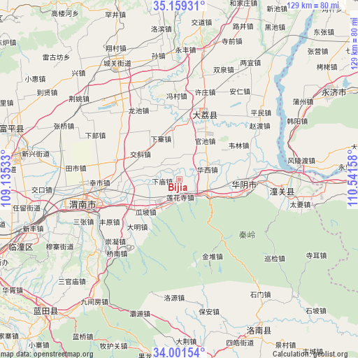
Bijia GPS coordinates[2]
34° 34' 56.784" North, 109° 50' 18.42" East
| Map corner | latitude | longitude |
|---|---|---|
| Upper-left | 35.15931°, | 109.13533° |
| Center: | 34.58244°, | 109.83845° |
| Lower-right: | 34.00154°, | 110.54158° |
| Map W x H: | 128.7×128.7 km | = 80×80mi |
| max Lat: | 53.31946° ⇑26.8% North |
| Bijia: | 34.58244° |
| min Lat: | ⇓73.2% South 18.22056° |
| min Long | Bijia | max Long |
| 75.07348° | 109.83845° | 134.28917° |
| W 27.9%⇐ | ⇒72.1% E |
Elevation
Elevation of Bijia is 339 m = 1112 ft, and this is 145.8 m = 478 ft below average elevation for this country.
| Max E: |
5622 m = 18445 ft | 34.2% |
| Avg. | 484.8 m = 1591 ft | |
| Bijia | 339 m = 1112 ft | |
Min E: |
-3 m = -10 ft | 65.8% |
See also: China elevation on elevation.city.
Geographical zone
Bijia is located in North temperate zone (between Tropic of Cancer and the Arctic Circle). Distance of this Northern Tropic circle is 1239.3 km =770.1 mi to South.| Distance of | km | miles | from Bijia |
|---|---|---|---|
| North Pole | 6161.9 | 3828.8 | to North |
| Arctic Circle | 3556 | 2209.6 | to North |
| Tropic Cancer | 1239.3 | 770.1 | to South |
| Equator | 3845.2 | 2389.3 | to South |


Nearby cities:
15 places around Bijia: (largest is in red/bold)
• Fushui
11.3 km =7 mi,  110°
110°
• Guanchi
16.3 km =10.1 mi,  34°
34°
• Guapo
16.8 km =10.4 mi,  226°
226°
• Huazhou
10.5 km =6.5 mi,  224°
224°
• Jiaoxie
16.7 km =10.4 mi,  303°
303°
• Lianhuasi
6.4 km =4 mi,  178°
178°
• Liuzhi
5.1 km =3.2 mi,  160°
160°
• Qiangbai
18.5 km =11.5 mi,  352°
352°
• Sucun
6.7 km =4.2 mi,  9°
9°
• Taoxia
13.5 km =8.4 mi, 108°
• Xiamiao
6.2 km =3.9 mi,  263°
263°
• Xiaoyi
13 km =8.1 mi,  287°
287°
• Xiazhai
16.1 km =10 mi,  335°
335°
• Xinglin
12.2 km =7.6 mi, 215°
• Zhangjia
10.1 km =6.3 mi, 292°
Sources, notices
• [Note1] Compared only with cities in China existing in our database
• [Src1] Map data: © OpenStreetMap contributors (CC-BY-SA)
• [Src2] Other city data from geonames.org with taken over terms of usage.
• [Src3] Geographical zone / Annual Mean Temperature by Robert A. Rohde @ Wikipedia
