Fenghuang geodata
Fenghuang (Jiangsu) is a seat of a fourth-order administrative division; located in China in Asia/Shanghai (GMT+8) time zone. In our database, there are 1268 cities with bigger population. Compared to other cities in China, 60.1% of cities are located further ↓South; 85.8% of cities are located further ←West and 98.9% of cities have higher elevation than Fenghuang. Note1


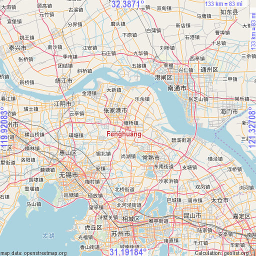
Fenghuang GPS coordinates[2]
31° 47' 29.04" North, 120° 37' 26.22" East
| Map corner | latitude | longitude |
|---|---|---|
| Upper-left | 32.3871°, | 119.92083° |
| Center: | 31.7914°, | 120.62395° |
| Lower-right: | 31.19184°, | 121.32708° |
| Map W x H: | 132.9×132.9 km | = 82.6×82.6mi |
| max Lat: | 53.31946° ⇑39.9% North |
| Fenghuang: | 31.7914° |
| min Lat: | ⇓60.1% South 18.22056° |
| min Long | Fenghuang | max Long |
| 75.07348° | 120.62395° | 134.28917° |
| W 85.8%⇐ | ⇒14.2% E |
Elevation
Elevation of Fenghuang is 3 m = 10 ft, and this is 481.8 m = 1581 ft below average elevation for this country.
| Max E: |
5622 m = 18445 ft | 98.9% |
| Avg. | 484.8 m = 1591 ft | |
| Fenghuang | 3 m = 10 ft | |
Min E: |
-3 m = -10 ft | 1.1% |
See also: China elevation on elevation.city.
Geographical zone
Fenghuang is located in North temperate zone (between Tropic of Cancer and the Arctic Circle). Distance of this Northern Tropic circle is 929 km =577.3 mi to South.| Distance of | km | miles | from Fenghuang |
|---|---|---|---|
| North Pole | 6472.2 | 4021.6 | to North |
| Arctic Circle | 3866.3 | 2402.4 | to North |
| Tropic Cancer | 929 | 577.3 | to South |
| Equator | 3534.9 | 2196.5 | to South |


Nearby cities:
15 places around Fenghuang: (largest is in red/bold)
• Changjing
14.4 km =8.9 mi,  253°
253°
• Changshu City
19.6 km =12.2 mi,  145°
145°
• Daxin
21.4 km =13.3 mi,  339°
339°
• Gushan
9.6 km =6 mi,  227°
227°
• Haiyu
17.3 km =10.7 mi,  104°
104°
• Huashi
15.9 km =9.9 mi,  287°
287°
• Jinfeng
19.1 km =11.9 mi,  6°
6°
• Leyu
16.8 km =10.4 mi,  24°
24°
• Nanfeng
10.6 km =6.6 mi, 21°
• Shanghu
13.6 km =8.5 mi,  178°
178°
• Xinqiao
11.3 km =7 mi,  276°
276°
• Yangjian
19.2 km =11.9 mi,  199°
199°
• Yushan
21 km =13 mi,  127°
127°
• Zhangjiagang
11.5 km =7.1 mi,  315°
315°
• Zhutang
20.5 km =12.7 mi,  263°
263°
Sources, notices
• [Note1] Compared only with cities in China existing in our database
• [Src1] Map data: © OpenStreetMap contributors (CC-BY-SA)
• [Src2] Other city data from geonames.org with taken over terms of usage.
• [Src3] Geographical zone / Annual Mean Temperature by Robert A. Rohde @ Wikipedia
