Beiqiao geodata
Beiqiao (Jiangsu) is a seat of a fourth-order administrative division; located in China in Asia/Shanghai (GMT+8) time zone. In our database, there are 1268 cities with bigger population. Compared to other cities in China, 58.5% of cities are located further ↓South; 85.7% of cities are located further ←West and 94.3% of cities have higher elevation than Beiqiao. Note1


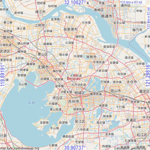
Beiqiao GPS coordinates[2]
31° 30' 31.464" North, 120° 35' 42.108" East
| Map corner | latitude | longitude |
|---|---|---|
| Upper-left | 32.10627°, | 119.89191° |
| Center: | 31.50874°, | 120.59503° |
| Lower-right: | 30.90737°, | 121.29816° |
| Map W x H: | 133.3×133.3 km | = 82.8×82.8mi |
| max Lat: | 53.31946° ⇑41.5% North |
| Beiqiao: | 31.50874° |
| min Lat: | ⇓58.5% South 18.22056° |
| min Long | Beiqiao | max Long |
| 75.07348° | 120.59503° | 134.28917° |
| W 85.7%⇐ | ⇒14.3% E |
Elevation
Elevation of Beiqiao is 7 m = 23 ft, and this is 477.8 m = 1568 ft below average elevation for this country.
| Max E: |
5622 m = 18445 ft | 94.3% |
| Avg. | 484.8 m = 1591 ft | |
| Beiqiao | 7 m = 23 ft | |
Min E: |
-3 m = -10 ft | 5.7% |
See also: China elevation on elevation.city.
Geographical zone
Beiqiao is located in North temperate zone (between Tropic of Cancer and the Arctic Circle). Distance of this Northern Tropic circle is 897.5 km =557.7 mi to South.| Distance of | km | miles | from Beiqiao |
|---|---|---|---|
| North Pole | 6503.6 | 4041.1 | to North |
| Arctic Circle | 3897.7 | 2421.9 | to North |
| Tropic Cancer | 897.5 | 557.7 | to South |
| Equator | 3503.4 | 2176.9 | to South |


Nearby cities:
15 places around Beiqiao: (largest is in red/bold)
• Anzhen
16.4 km =10.2 mi,  313°
313°
• Ehu
5.3 km =3.3 mi,  290°
290°
• Hongshan
10.1 km =6.3 mi,  255°
255°
• Huangdai
8.9 km =5.5 mi,  204°
204°
• Meicun
16.2 km =10.1 mi,  284°
284°
• Shanghu
18.1 km =11.2 mi,  9°
9°
• Shuofang
14.9 km =9.3 mi, 261°
• Taiping
12.7 km =7.9 mi,  130°
130°
• Wangting
16.5 km =10.3 mi,  242°
242°
• Weitang
6.8 km =4.2 mi,  135°
135°
• Xinzhuang
9.4 km =5.8 mi,  70°
70°
• Xushuguan
17 km =10.6 mi,  212°
212°
• Yangdenghu
12.3 km =7.6 mi,  97°
97°
• Yangjian
13.9 km =8.6 mi,  343°
343°
• Yuanhe
12.3 km =7.6 mi,  171°
171°
Sources, notices
• [Note1] Compared only with cities in China existing in our database
• [Src1] Map data: © OpenStreetMap contributors (CC-BY-SA)
• [Src2] Other city data from geonames.org with taken over terms of usage.
• [Src3] Geographical zone / Annual Mean Temperature by Robert A. Rohde @ Wikipedia
