Luoda geodata
Luoda (Gansu) is a seat of a fourth-order administrative division; located in China in Asia/Shanghai (GMT+8) time zone. In our database, there are 1268 cities with bigger population. Compared to other cities in China, 70% of cities are located further ↓South; 90.3% of cities are located further →East and 93% of cities have lower elevation than Luoda. Note1


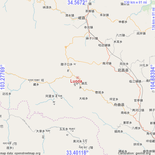
Luoda GPS coordinates[2]
33° 59' 10.284" North, 103° 58' 50.916" East
| Map corner | latitude | longitude |
|---|---|---|
| Upper-left | 34.5672°, | 103.27769° |
| Center: | 33.98619°, | 103.98081° |
| Lower-right: | 33.40118°, | 104.68394° |
| Map W x H: | 129.6×129.6 km | = 80.5×80.5mi |
| max Lat: | 53.31946° ⇑30% North |
| Luoda: | 33.98619° |
| min Lat: | ⇓70% South 18.22056° |
| min Long | Luoda | max Long |
| 75.07348° | 103.98081° | 134.28917° |
| W 9.7%⇐ | ⇒90.3% E |
Elevation
Elevation of Luoda is 1704 m = 5591 ft, and this is 1219.2 m = 4000 ft above average elevation for this country.
| Max E: |
5622 m = 18445 ft | 7% |
| Luoda | 1704 m 5591 ft | |
| Avg. | 484.8 m = 1591 ft | |
Min E: |
-3 m = -10 ft | 93% |
See also: China elevation on elevation.city.
Geographical zone
Luoda is located in North temperate zone (between Tropic of Cancer and the Arctic Circle). Distance of this Northern Tropic circle is 1173 km =728.9 mi to South.| Distance of | km | miles | from Luoda |
|---|---|---|---|
| North Pole | 6228.2 | 3870 | to North |
| Arctic Circle | 3622.3 | 2250.8 | to North |
| Tropic Cancer | 1173 | 728.9 | to South |
| Equator | 3778.9 | 2348.1 | to South |


Nearby cities:
15 places around Luoda: (largest is in red/bold)
• Bazang
10.8 km =6.7 mi,  151°
151°
• Dayu
18.1 km =11.2 mi,  162°
162°
• Fengdie
31.2 km =19.4 mi,  128°
128°
• Guan’e
38.2 km =23.7 mi,  85°
85°
• Hadapu Zhen
35.2 km =21.9 mi,  39°
39°
• Hanban
22.6 km =14 mi,  123°
123°
• Hejiabao
31.4 km =19.5 mi,  79°
79°
• Huayuan
19.8 km =12.3 mi,  263°
263°
• Lazi
12 km =7.5 mi,  318°
318°
• Lijie
12.5 km =7.8 mi,  138°
138°
• Nanhe
27.4 km =17 mi,  63°
63°
• Pingding
35.3 km =21.9 mi, 120°
• Quwa
7.6 km =4.7 mi,  171°
171°
• Sangba
18.5 km =11.5 mi,  288°
288°
• Wangcang
35.3 km =21.9 mi, 263°
Sources, notices
• [Note1] Compared only with cities in China existing in our database
• [Src1] Map data: © OpenStreetMap contributors (CC-BY-SA)
• [Src2] Other city data from geonames.org with taken over terms of usage.
• [Src3] Geographical zone / Annual Mean Temperature by Robert A. Rohde @ Wikipedia
