Lazi geodata
Lazi (Gansu) is a seat of a fourth-order administrative division; located in China in Asia/Shanghai (GMT+8) time zone. In our database, there are 1268 cities with bigger population. Compared to other cities in China, 70.4% of cities are located further ↓South; 90.4% of cities are located further →East and 94.5% of cities have lower elevation than Lazi. Note1


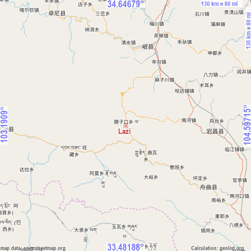
Lazi GPS coordinates[2]
34° 3' 58.824" North, 103° 53' 38.472" East
| Map corner | latitude | longitude |
|---|---|---|
| Upper-left | 34.64679°, | 103.1909° |
| Center: | 34.06634°, | 103.89402° |
| Lower-right: | 33.48188°, | 104.59715° |
| Map W x H: | 129.5×129.5 km | = 80.5×80.5mi |
| max Lat: | 53.31946° ⇑29.6% North |
| Lazi: | 34.06634° |
| min Lat: | ⇓70.4% South 18.22056° |
| min Long | Lazi | max Long |
| 75.07348° | 103.89402° | 134.28917° |
| W 9.6%⇐ | ⇒90.4% E |
Elevation
Elevation of Lazi is 1949 m = 6394 ft, and this is 1464.2 m = 4804 ft above average elevation for this country.
| Max E: |
5622 m = 18445 ft | 5.5% |
| Lazi | 1949 m 6394 ft | |
| Avg. | 484.8 m = 1591 ft | |
Min E: |
-3 m = -10 ft | 94.5% |
See also: China elevation on elevation.city.
Geographical zone
Lazi is located in North temperate zone (between Tropic of Cancer and the Arctic Circle). Distance of this Northern Tropic circle is 1181.9 km =734.4 mi to South.| Distance of | km | miles | from Lazi |
|---|---|---|---|
| North Pole | 6219.2 | 3864.4 | to North |
| Arctic Circle | 3613.4 | 2245.3 | to North |
| Tropic Cancer | 1181.9 | 734.4 | to South |
| Equator | 3787.8 | 2353.6 | to South |


Nearby cities:
15 places around Lazi: (largest is in red/bold)
• Bazang
22.6 km =14 mi,  144°
144°
• Dayu
29.4 km =18.3 mi,  152°
152°
• Hadapu Zhen
35.4 km =22 mi,  58°
58°
• Hanban
34.3 km =21.3 mi,  128°
128°
• Huayuan
16.1 km =10 mi,  226°
226°
• Kaba
38 km =23.6 mi,  255°
255°
• Lijie
24.5 km =15.2 mi, 138°
• Luoda
12 km =7.5 mi, 138°
• Nanhe
32.7 km =20.3 mi,  84°
84°
• Ni’ao
33.8 km =21 mi,  249°
249°
• Qinxu
34.8 km =21.6 mi,  15°
15°
• Quwa
18.8 km =11.7 mi, 150°
• Sangba
10 km =6.2 mi, 252°
• Sigou
37.4 km =23.2 mi,  27°
27°
• Wangcang
30 km =18.6 mi,  244°
244°
Sources, notices
• [Note1] Compared only with cities in China existing in our database
• [Src1] Map data: © OpenStreetMap contributors (CC-BY-SA)
• [Src2] Other city data from geonames.org with taken over terms of usage.
• [Src3] Geographical zone / Annual Mean Temperature by Robert A. Rohde @ Wikipedia
